NOAA HRRR analysis validation report
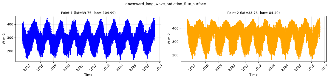
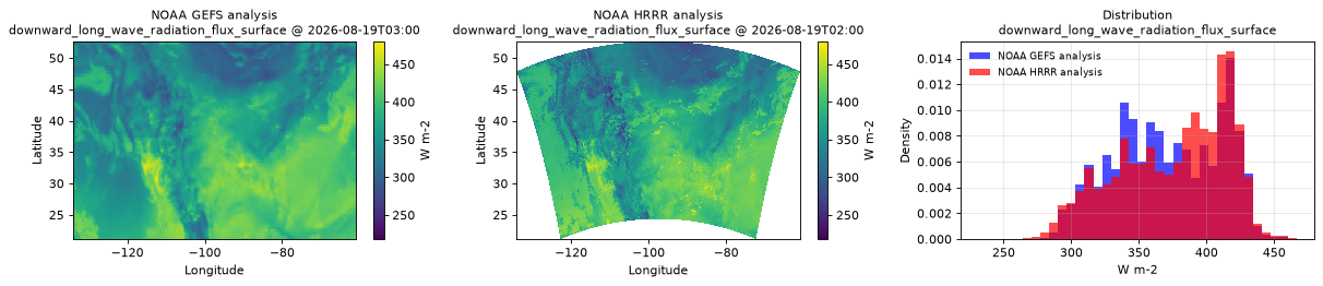
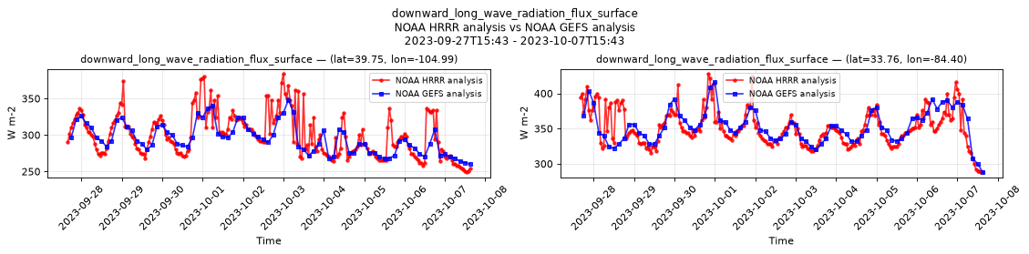
This dataset validation report plots a sample of values from the NOAA HRRR analysis dataset over time and across space, comparing where possible to a previously validated reference dataset. It also reports the quantity of unavailable values and their associated timestamps. These analyses are one layer of a multi-layered dataset validation process we perform at dynamical.org and also provide users a preview of the dataset contents.
Report generation start time: 2026-08-19T18:38:51 UTC
Summary
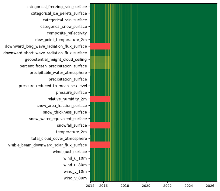
This dataset has been reviewed and is ready for use. Two things are worth knowing before you start: visible beam downward solar flux needs a simple mask applied (see below), and source data is missing for a scattered 2% of hours before late 2020.
What looks good
- Geographic placement, map projection and grid coordinates are correct on every variable, checked against a second independent archive and against known coastlines and terrain.
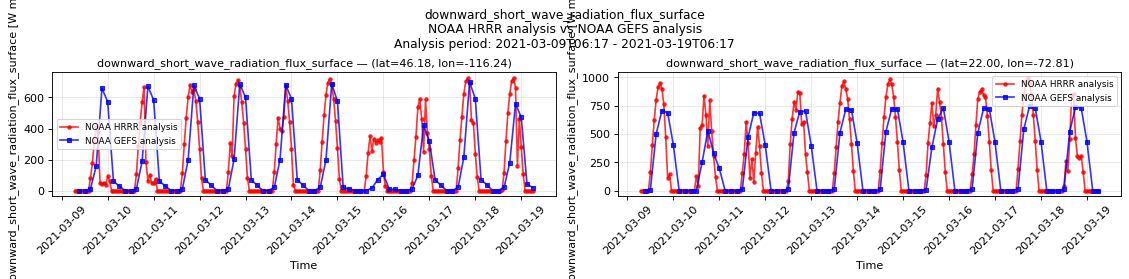
- Timestamps are correct, independently confirmed by the position of sunrise and sunset: the two shortwave radiation variables go to zero exactly where the sun is below the horizon at each hour.
- Units and physical ranges are correct, including the conversions applied to snow cover (to a fraction) and snow water equivalent (to metres). Snow depth and snow water equivalent give realistic snow-to-water ratios.
- Related variables agree with each other: radar reflectivity, precipitation, categorical rain and cloud cover all activate over the same areas; cloud ceiling heights appear when cloud cover is high; percent frozen precipitation matches where the categorical snow flag is set.
- Missing-data markers are handled completely for cloud ceiling height and percent frozen precipitation — every one of the source's markers becomes a NaN, with none left behind as a raw number.
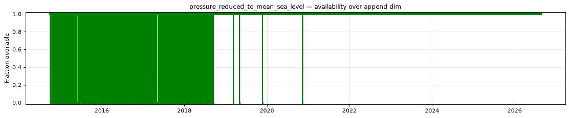
- Values are stable across the model's version upgrades, with no artificial jumps where the source changed how it labels mean sea level pressure in July 2018.
- A February 2021 winter storm reproduces correctly, with snow cover extending to the Texas coast and matching an independent archive closely.
Review notes
- The 10 and 80 metre wind components follow the model grid's axes, not east and north. The HRRR runs on a Lambert-conformal grid and its source files resolve the u and v components to that grid, so u is not eastward velocity and v is not northward velocity. They are equivalent to eastward and northward winds along the centre of the model's domain and become offset by up to 22.8 degrees at its eastern and western edges.
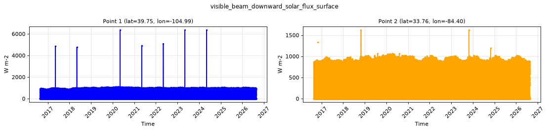
- Mask visible beam downward solar flux above 1,361 W m-2, the solar constant. A thin band of grid cells at sunrise carries impossible values, up to about 10,000. The variable is direct normal irradiance, measured perpendicular to the sun's rays, so it legitimately exceeds the surface shortwave flux when the sun is low and genuine values reach about 1,100 — masking any lower discards real data. The inflation grows smoothly into that range, so treat the first hour of daylight at any location as unreliable.
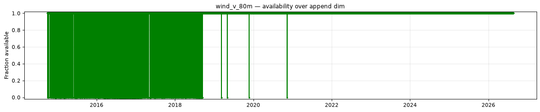
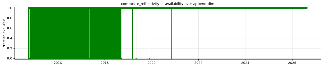
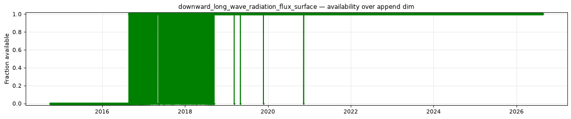
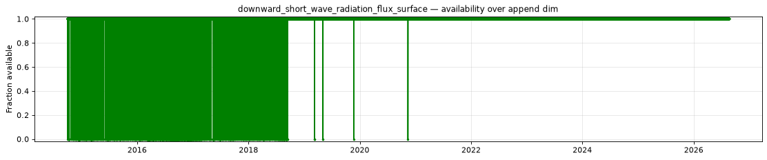
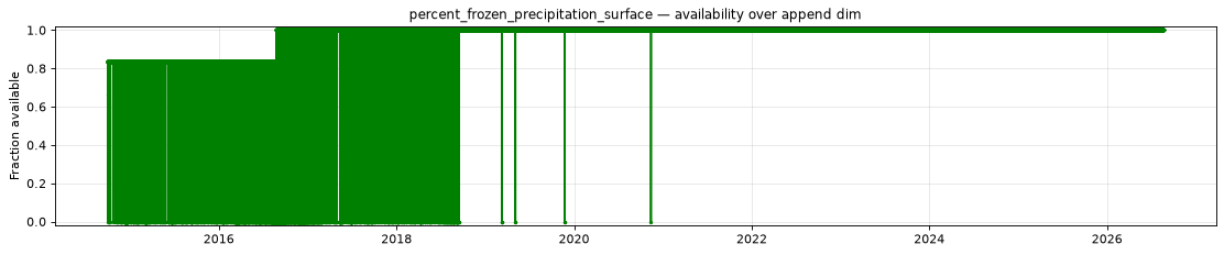
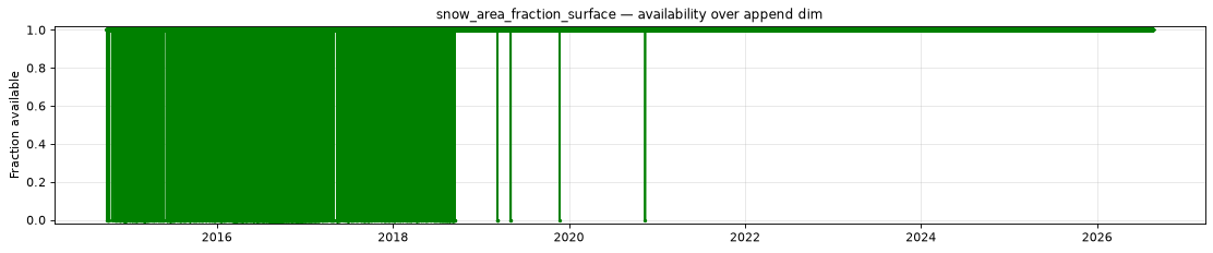
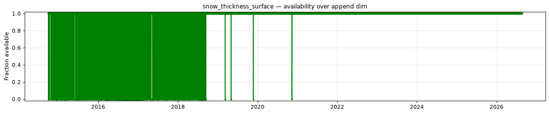
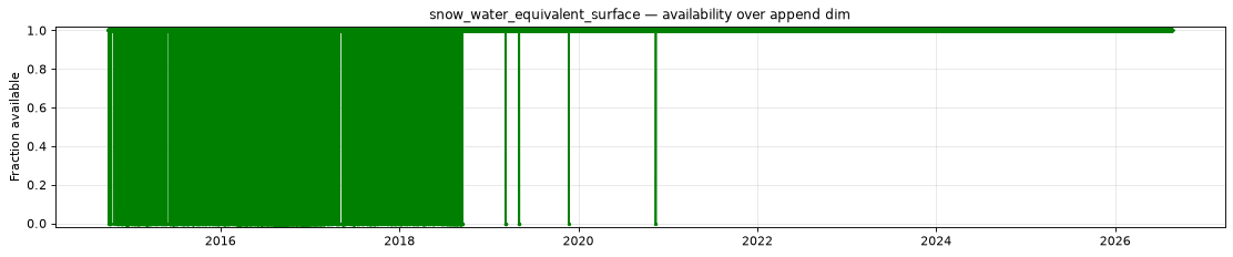
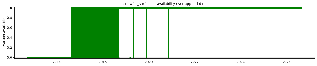
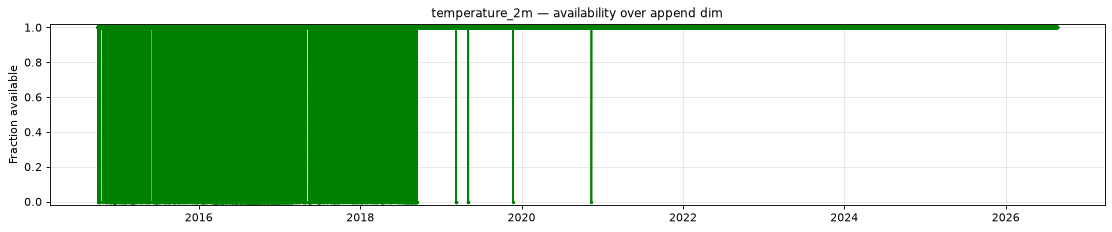
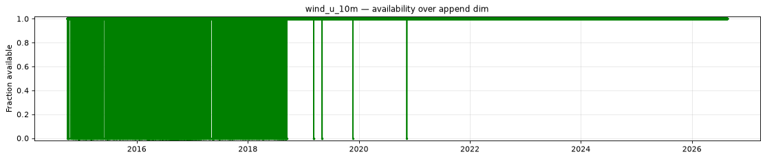
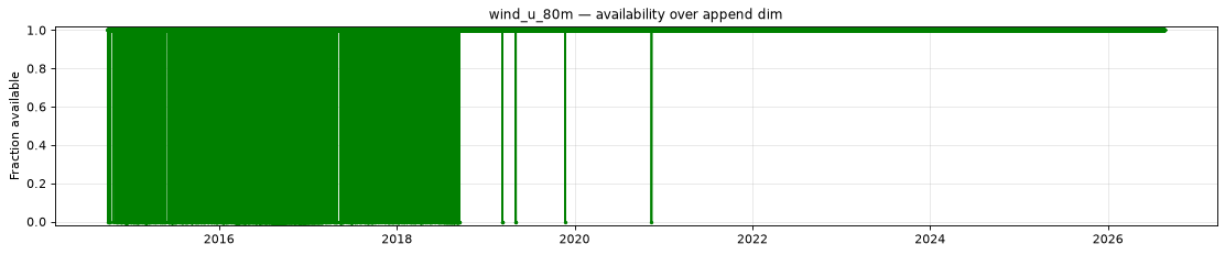
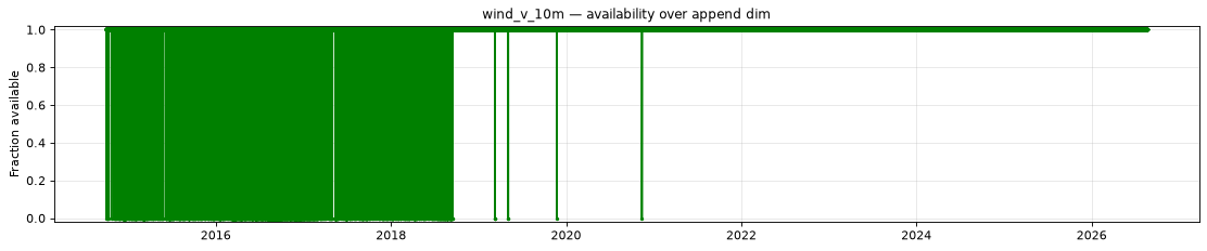
- Source data is missing for about 2% of hours before 2020-11-12; the record is complete after that. Roughly 2,050 hours, the same ones for every variable, concentrated in 2016 (1,108 hours) and thinning through 2019. The longest single gap runs 86 hours, 2016-03-18 to 2016-03-21. These files do not exist in the upstream archive, so the gaps cannot be filled.
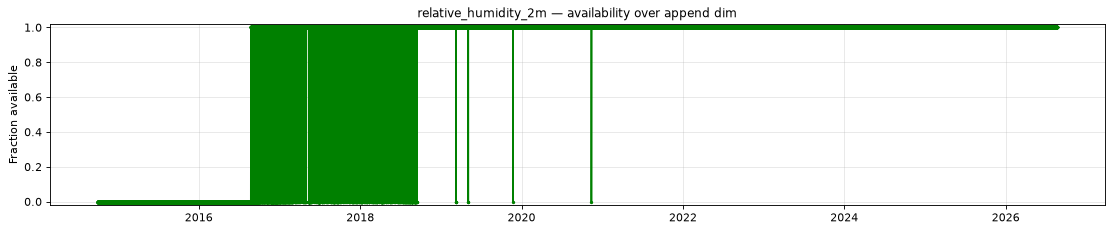
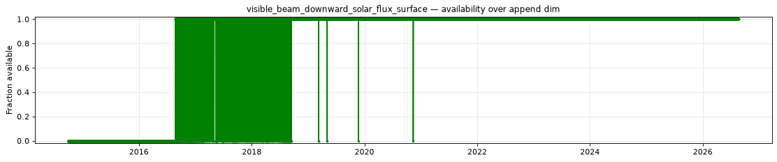
- Four variables start on 2016-08-23, when the second version of the HRRR model began producing them. Surface downward long-wave radiation flux, 2 metre relative humidity and visible beam downward solar flux from 14:00; total snowfall rate from 15:00.
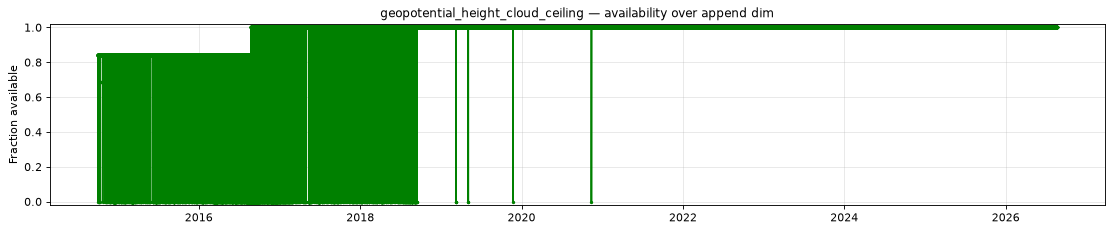
- Cloud ceiling height and percent frozen precipitation are present from the start of the record, despite the availability figures below. A NaN in these two means "no cloud ceiling" and "no precipitation", so their coverage cannot be measured directly and is inferred from other variables in the same source files, which is why it inherits the 2016 dates above.
Datasets
| Role | Name | ID | Version | URL |
|---|---|---|---|---|
| Validation | NOAA HRRR analysis | noaa-hrrr-analysis |
v0.2.0 |
s3://dynamical-noaa-hrrr/noaa-hrrr-analysis/v0.2.0.icechunk |
| Reference | NOAA GEFS analysis | noaa-gefs-analysis |
0.1.2 |
s3://dynamical-noaa-gefs/noaa-gefs-analysis/v0.1.2.icechunk/ |
Run parameters
| Parameter | Value |
|---|---|
| Validation dataset type | analysis |
| Validation time range | time 2014-10-01T00:00 → 2026-08-19T14:00 |
| Reference time range | time 2000-01-01T00:00 → 2026-08-19T12:00 |
| Point 1 | lat=39.7469, lon=-104.9864 |
| Point 2 | lat=33.7598, lon=-84.3952 |
| Spatial comparison time | 2026-08-19T02:00 (reference at 2026-08-19T03:00) |
| Timeseries period | 2023-09-27T15:43 - 2023-10-07T15:43 |
Availability
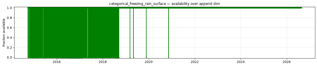
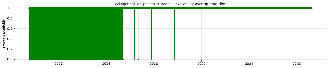
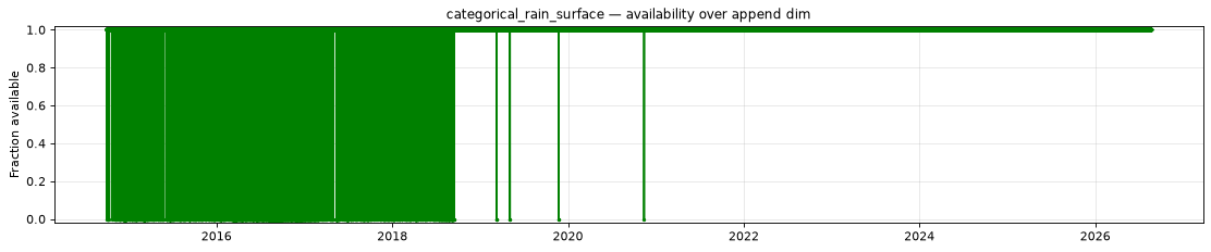
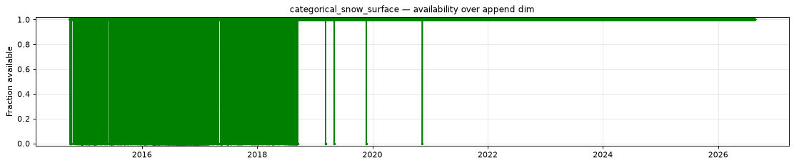
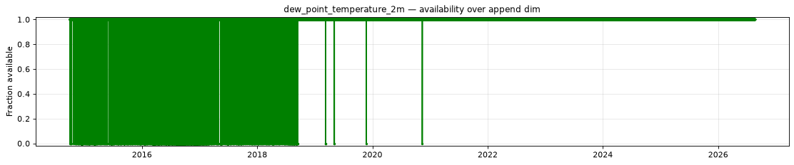
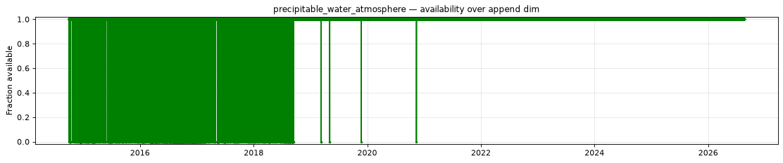
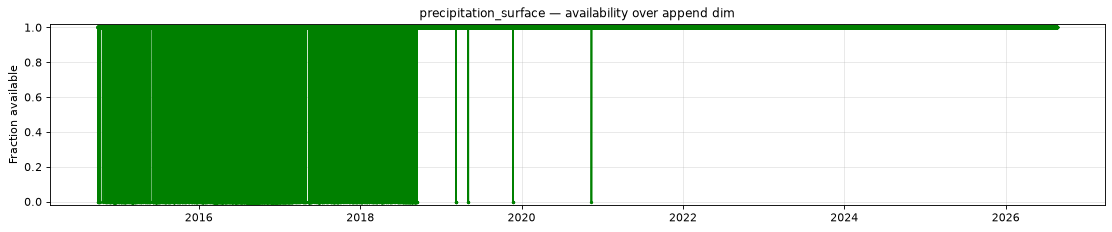
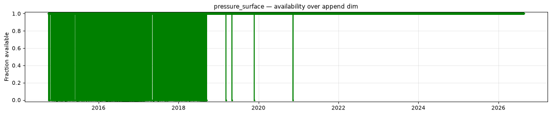
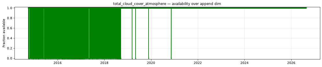
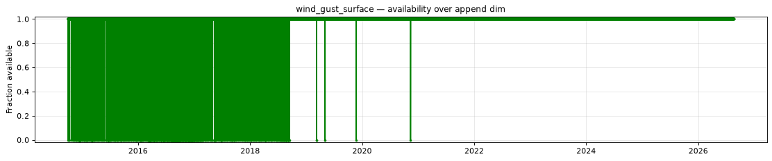
The plot below shows the availability of each variable over time — light red marks unavailable data, dark green marks present data.
| Variable | Complete positions | Incomplete % | First incomplete | Last incomplete |
|---|---|---|---|---|
categorical_freezing_rain_surface |
102117/104175 | 1.98% | 2014-10-02T13:00 | 2020-11-12T10:00 |
categorical_ice_pellets_surface |
102117/104175 | 1.98% | 2014-10-02T13:00 | 2020-11-12T10:00 |
categorical_rain_surface |
102117/104175 | 1.98% | 2014-10-02T13:00 | 2020-11-12T10:00 |
categorical_snow_surface |
102117/104175 | 1.98% | 2014-10-02T13:00 | 2020-11-12T10:00 |
composite_reflectivity |
102123/104175 | 1.97% | 2014-10-02T12:00 | 2020-11-12T09:00 |
dew_point_temperature_2m |
102121/104175 | 1.97% | 2014-10-02T12:00 | 2020-11-12T09:00 |
downward_long_wave_radiation_flux_surface |
86515/104175 | 16.95% | 2014-10-01T00:00 | 2020-11-12T09:00 |
downward_short_wave_radiation_flux_surface |
102108/104175 | 1.98% | 2014-10-02T12:00 | 2020-11-12T09:00 |
geopotential_height_cloud_ceiling |
86515/104175 | 16.95% | 2014-10-01T00:00 | 2020-11-12T09:00 |
percent_frozen_precipitation_surface |
86514/104175 | 16.95% | 2014-10-01T00:00 | 2020-11-12T10:00 |
precipitable_water_atmosphere |
102108/104175 | 1.98% | 2014-10-02T12:00 | 2020-11-12T09:00 |
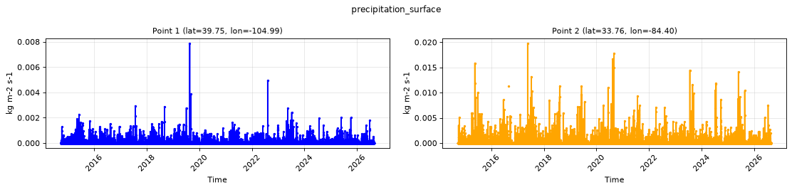
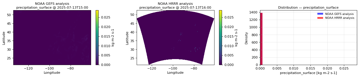
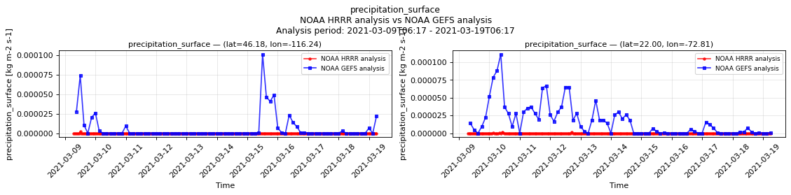
precipitation_surface |
102116/104175 | 1.98% | 2014-10-01T00:00 | 2020-11-12T10:00 |
pressure_reduced_to_mean_sea_level |
102122/104175 | 1.97% | 2014-10-02T12:00 | 2020-11-12T09:00 |
pressure_surface |
102122/104175 | 1.97% | 2014-10-02T12:00 | 2020-11-12T09:00 |
relative_humidity_2m |
86515/104175 | 16.95% | 2014-10-01T00:00 | 2020-11-12T09:00 |
snow_area_fraction_surface |
102121/104175 | 1.97% | 2014-10-02T12:00 | 2020-11-12T09:00 |
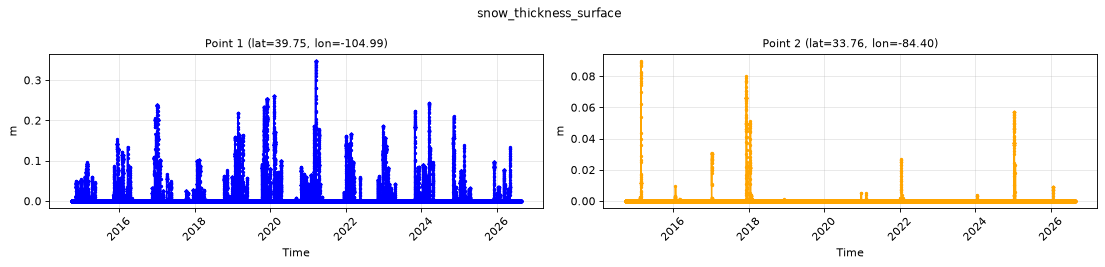
snow_thickness_surface |
102121/104175 | 1.97% | 2014-10-02T12:00 | 2020-11-12T09:00 |
snow_water_equivalent_surface |
102121/104175 | 1.97% | 2014-10-02T12:00 | 2020-11-12T09:00 |
snowfall_surface |
86514/104175 | 16.95% | 2014-10-01T00:00 | 2020-11-12T10:00 |
temperature_2m |
102121/104175 | 1.97% | 2014-10-02T12:00 | 2020-11-12T09:00 |
total_cloud_cover_atmosphere |
102108/104175 | 1.98% | 2014-10-02T12:00 | 2020-11-12T09:00 |
visible_beam_downward_solar_flux_surface |
86515/104175 | 16.95% | 2014-10-01T00:00 | 2020-11-12T09:00 |
wind_gust_surface |
102123/104175 | 1.97% | 2014-10-02T12:00 | 2020-11-12T09:00 |
wind_u_10m |
102121/104175 | 1.97% | 2014-10-02T12:00 | 2020-11-12T09:00 |
wind_u_80m |
102122/104175 | 1.97% | 2014-10-02T12:00 | 2020-11-12T09:00 |
wind_v_10m |
102121/104175 | 1.97% | 2014-10-02T12:00 | 2020-11-12T09:00 |
wind_v_80m |
102122/104175 | 1.97% | 2014-10-02T12:00 | 2020-11-12T09:00 |
- Unavailable timestamps:
unavailable_timestamps.txt
Per-variable details
categorical_freezing_rain_surface
Metadata
| Field | Value |
|---|---|
| units | 1 |
| long_name | Categorical freezing rain |
| short_name | cfrzr |
| standard_name | n/a |
| step_type | instant |
| flag_values | 0, 1 |
| flag_meanings | no yes |
| comment | 0=no; 1=yes |
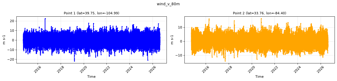
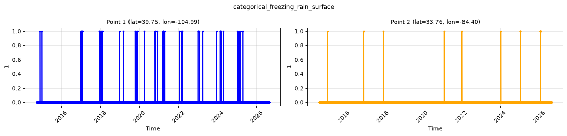
Point time series — 2014-10-01T00:00 - 2026-08-19T14:00
| Point | min | mean | max |
|---|---|---|---|
| P1 | 0 | 0.0007736 | 1 |
| P2 | 0 | 0.0003623 | 1 |
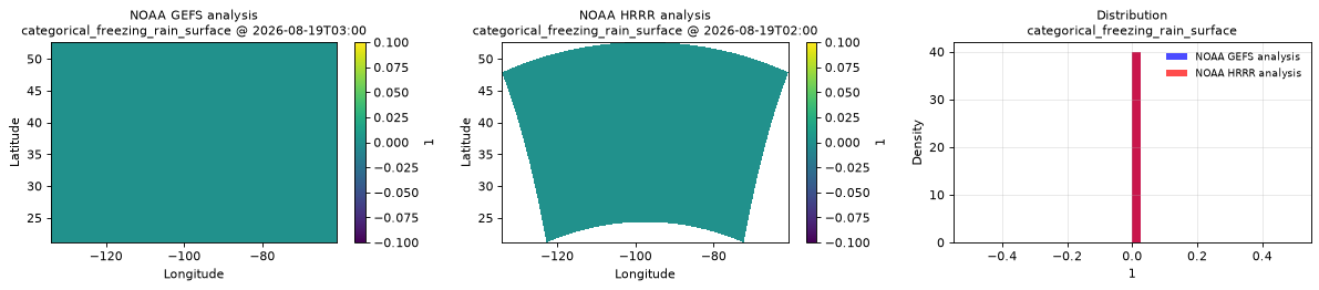
Spatial — 2026-08-19T02:00 (reference at 2026-08-19T03:00)
| Source | min | mean | max |
|---|---|---|---|
| Validation | 0 | 0 | 0 |
| Reference | 0 | 0 | 0 |
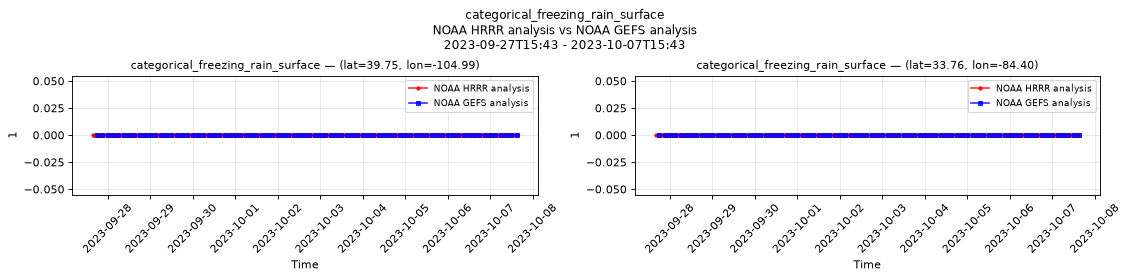
Temporal — 2023-09-27T15:43 - 2023-10-07T15:43
| Source | min | mean | max |
|---|---|---|---|
| P1 Validation | 0 | 0 | 0 |
| P1 Reference | 0 | 0 | 0 |
| P2 Validation | 0 | 0 | 0 |
| P2 Reference | 0 | 0 | 0 |
Availability — 102117 of 104175 positions complete (incomplete 2014-10-02T13:00 → 2020-11-12T10:00); nulls P1 2058/104175, P2 2058/104175
categorical_ice_pellets_surface
Metadata
| Field | Value |
|---|---|
| units | 1 |
| long_name | Categorical ice pellets |
| short_name | cicep |
| standard_name | n/a |
| step_type | instant |
| flag_values | 0, 1 |
| flag_meanings | no yes |
| comment | 0=no; 1=yes |
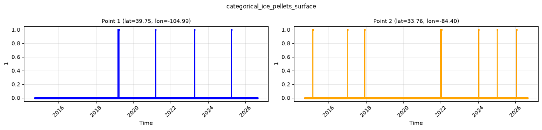
Point time series — 2014-10-01T00:00 - 2026-08-19T14:00
| Point | min | mean | max |
|---|---|---|---|
| P1 | 0 | 5.876e-05 | 1 |
| P2 | 0 | 0.0002252 | 1 |
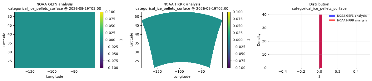
Spatial — 2026-08-19T02:00 (reference at 2026-08-19T03:00)
| Source | min | mean | max |
|---|---|---|---|
| Validation | 0 | 0 | 0 |
| Reference | 0 | 0 | 0 |
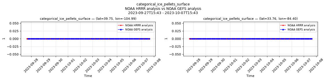
Temporal — 2023-09-27T15:43 - 2023-10-07T15:43
| Source | min | mean | max |
|---|---|---|---|
| P1 Validation | 0 | 0 | 0 |
| P1 Reference | 0 | 0 | 0 |
| P2 Validation | 0 | 0 | 0 |
| P2 Reference | 0 | 0 | 0 |
Availability — 102117 of 104175 positions complete (incomplete 2014-10-02T13:00 → 2020-11-12T10:00); nulls P1 2058/104175, P2 2058/104175
categorical_rain_surface
Metadata
| Field | Value |
|---|---|
| units | 1 |
| long_name | Categorical rain |
| short_name | crain |
| standard_name | n/a |
| step_type | instant |
| flag_values | 0, 1 |
| flag_meanings | no yes |
| comment | 0=no; 1=yes |
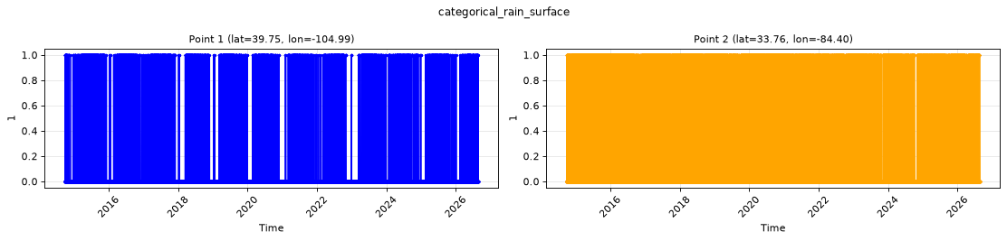
Point time series — 2014-10-01T00:00 - 2026-08-19T14:00
| Point | min | mean | max |
|---|---|---|---|
| P1 | 0 | 0.05251 | 1 |
| P2 | 0 | 0.141 | 1 |
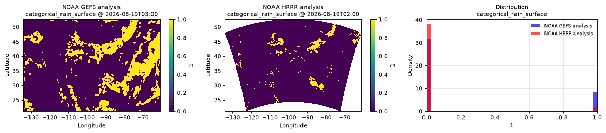
Spatial — 2026-08-19T02:00 (reference at 2026-08-19T03:00)
| Source | min | mean | max |
|---|---|---|---|
| Validation | 0 | 0.04194 | 1 |
| Reference | 0 | 0.2122 | 1 |
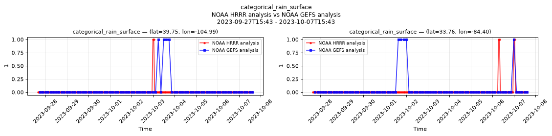
Temporal — 2023-09-27T15:43 - 2023-10-07T15:43
| Source | min | mean | max |
|---|---|---|---|
| P1 Validation | 0 | 0.008333 | 1 |
| P1 Reference | 0 | 0.05 | 1 |
| P2 Validation | 0 | 0.01667 | 1 |
| P2 Reference | 0 | 0.0625 | 1 |
Availability — 102117 of 104175 positions complete (incomplete 2014-10-02T13:00 → 2020-11-12T10:00); nulls P1 2058/104175, P2 2058/104175
categorical_snow_surface
Metadata
| Field | Value |
|---|---|
| units | 1 |
| long_name | Categorical snow |
| short_name | csnow |
| standard_name | n/a |
| step_type | instant |
| flag_values | 0, 1 |
| flag_meanings | no yes |
| comment | 0=no; 1=yes |
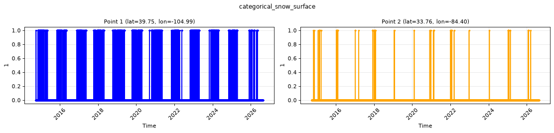
Point time series — 2014-10-01T00:00 - 2026-08-19T14:00
| Point | min | mean | max |
|---|---|---|---|
| P1 | 0 | 0.04658 | 1 |
| P2 | 0 | 0.001792 | 1 |
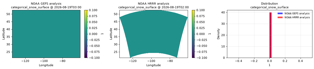
Spatial — 2026-08-19T02:00 (reference at 2026-08-19T03:00)
| Source | min | mean | max |
|---|---|---|---|
| Validation | 0 | 0 | 0 |
| Reference | 0 | 0 | 0 |
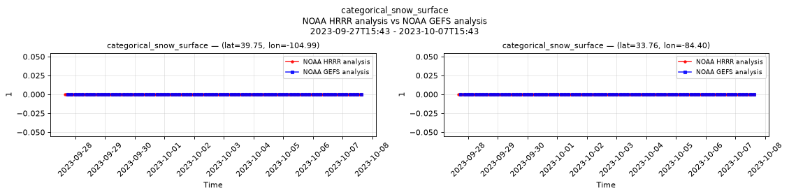
Temporal — 2023-09-27T15:43 - 2023-10-07T15:43
| Source | min | mean | max |
|---|---|---|---|
| P1 Validation | 0 | 0 | 0 |
| P1 Reference | 0 | 0 | 0 |
| P2 Validation | 0 | 0 | 0 |
| P2 Reference | 0 | 0 | 0 |
Availability — 102117 of 104175 positions complete (incomplete 2014-10-02T13:00 → 2020-11-12T10:00); nulls P1 2058/104175, P2 2058/104175
composite_reflectivity
Metadata
| Field | Value |
|---|---|
| units | dBZ |
| long_name | Maximum/Composite radar reflectivity |
| short_name | refc |
| standard_name | equivalent_reflectivity_factor |
| step_type | instant |
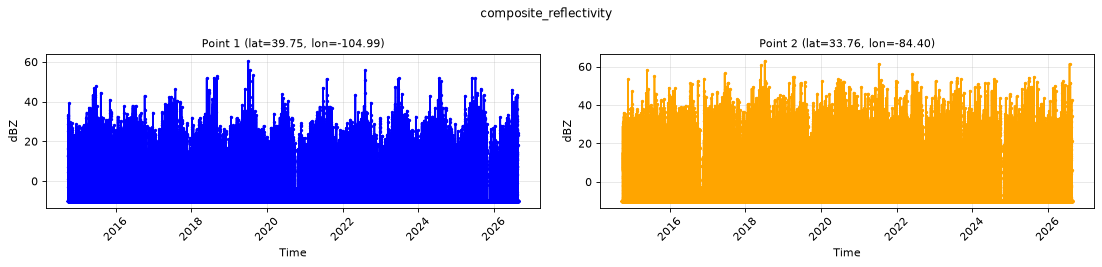
Point time series — 2014-10-01T00:00 - 2026-08-19T14:00
| Point | min | mean | max |
|---|---|---|---|
| P1 | -10 | -7.085 | 60.5 |
| P2 | -10 | -6.214 | 63 |
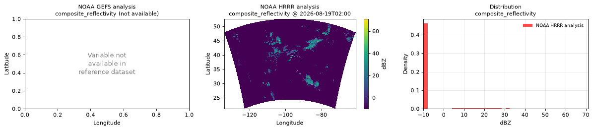
Spatial — 2026-08-19T02:00 (reference not available)
| Source | min | mean | max |
|---|---|---|---|
| Validation | -10 | -8.442 | 71 |
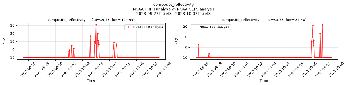
Temporal — 2023-09-27T15:43 - 2023-10-07T15:43
| Source | min | mean | max |
|---|---|---|---|
| P1 Validation | -10 | -8.838 | 30.75 |
| P2 Validation | -10 | -9.301 | 21.75 |
Availability — 102123 of 104175 positions complete (incomplete 2014-10-02T12:00 → 2020-11-12T09:00); nulls P1 2052/104175, P2 2052/104175
dew_point_temperature_2m
Metadata
| Field | Value |
|---|---|
| units | degree_Celsius |
| long_name | 2 metre dewpoint temperature |
| short_name | 2d |
| standard_name | dew_point_temperature |
| step_type | instant |
Point time series — 2014-10-01T00:00 - 2026-08-19T14:00
| Point | min | mean | max |
|---|---|---|---|
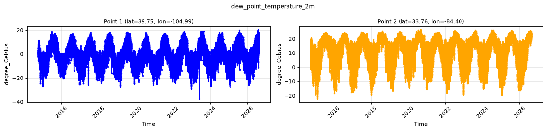
| P1 | -37.5 | -1.055 | 20.38 |
| P2 | -22.12 | 11.16 | 26.25 |
Spatial — 2026-08-19T02:00 (reference not available)
| Source | min | mean | max |
|---|---|---|---|
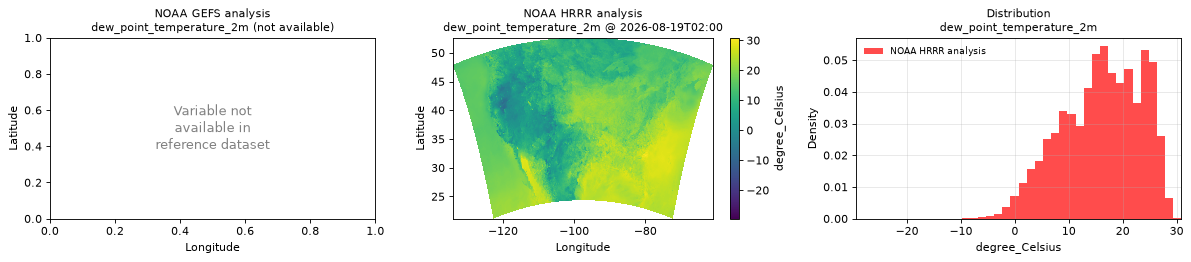
| Validation | -29.5 | 16.06 | 30.88 |
Temporal — 2023-09-27T15:43 - 2023-10-07T15:43
| Source | min | mean | max |
|---|---|---|---|
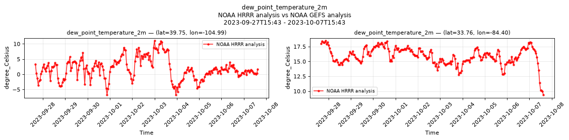
| P1 Validation | -6.781 | 1.803 | 11.06 |
| P2 Validation | 9.375 | 15.89 | 18.5 |
Availability — 102121 of 104175 positions complete (incomplete 2014-10-02T12:00 → 2020-11-12T09:00); nulls P1 2054/104175, P2 2054/104175
downward_long_wave_radiation_flux_surface
Metadata
| Field | Value |
|---|---|
| units | W m-2 |
| long_name | Surface downward long-wave radiation flux |
| short_name | sdlwrf |
| standard_name | surface_downwelling_longwave_flux_in_air |
| step_type | instant |
Point time series — 2014-10-01T00:00 - 2026-08-19T14:00
| Point | min | mean | max |
|---|---|---|---|
| P1 | 137 | 284.3 | 446 |
| P2 | 167 | 341.5 | 476 |
Spatial — 2026-08-19T02:00 (reference at 2026-08-19T03:00)
| Source | min | mean | max |
|---|---|---|---|
| Validation | 218 | 375.7 | 480 |
| Reference | 276 | 371.1 | 472 |
Temporal — 2023-09-27T15:43 - 2023-10-07T15:43
| Source | min | mean | max |
|---|---|---|---|
| P1 Validation | 249 | 300.1 | 384 |
| P1 Reference | 260 | 295.1 | 348 |
| P2 Validation | 288 | 350.9 | 428 |
| P2 Reference | 288 | 353 | 416 |
Availability — 86515 of 104175 positions complete (incomplete 2014-10-01T00:00 → 2020-11-12T09:00); nulls P1 17660/104175, P2 17660/104175
downward_short_wave_radiation_flux_surface
Metadata
| Field | Value |
|---|---|
| units | W m-2 |
| long_name | Surface downward short-wave radiation flux |
| short_name | sdswrf |
| standard_name | surface_downwelling_shortwave_flux_in_air |
| step_type | instant |
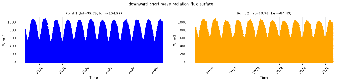
Point time series — 2014-10-01T00:00 - 2026-08-19T14:00
| Point | min | mean | max |
|---|---|---|---|
| P1 | 0 | 202.2 | 1088 |
| P2 | 0 | 185.9 | 1088 |
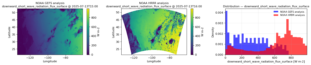
Spatial — 2026-08-19T02:00 (reference at 2026-08-19T03:00)
| Source | min | mean | max |
|---|---|---|---|
| Validation | 0 | 13.52 | 266 |
| Reference | 0 | 75.74 | 380 |
Temporal — 2023-09-27T15:43 - 2023-10-07T15:43
| Source | min | mean | max |
|---|---|---|---|
| P1 Validation | 0 | 195.6 | 808 |
| P1 Reference | 0 | 214.6 | 768 |
| P2 Validation | 0 | 202.3 | 820 |
| P2 Reference | 0 | 223.6 | 680 |
Availability — 102108 of 104175 positions complete (incomplete 2014-10-02T12:00 → 2020-11-12T09:00); nulls P1 2067/104175, P2 2067/104175
geopotential_height_cloud_ceiling
Metadata
| Field | Value |
|---|---|
| units | m |
| long_name | Geopotential height |
| short_name | gh |
| standard_name | geopotential_height |
| step_type | instant |
| comment | NaN where no cloud ceiling was detected. |
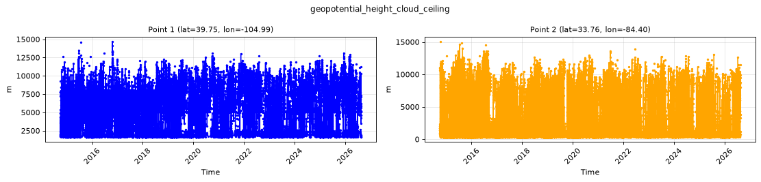
Point time series — 2014-10-01T00:00 - 2026-08-19T14:00
| Point | min | mean | max |
|---|---|---|---|
| P1 | 1628 | 4784 | 1.469e+04 |
| P2 | 341 | 2103 | 1.507e+04 |
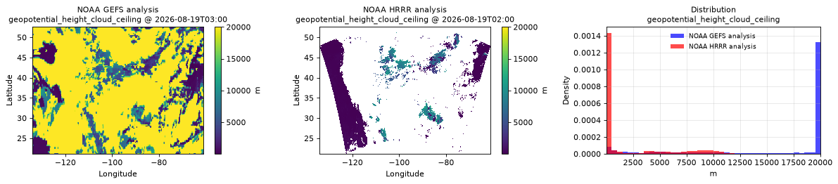
Spatial — 2026-08-19T02:00 (reference at 2026-08-19T03:00)
| Source | min | mean | max |
|---|---|---|---|
| Validation | 38.5 | 1993 | 1.526e+04 |
| Reference | 21.38 | 1.584e+04 | 2.003e+04 |
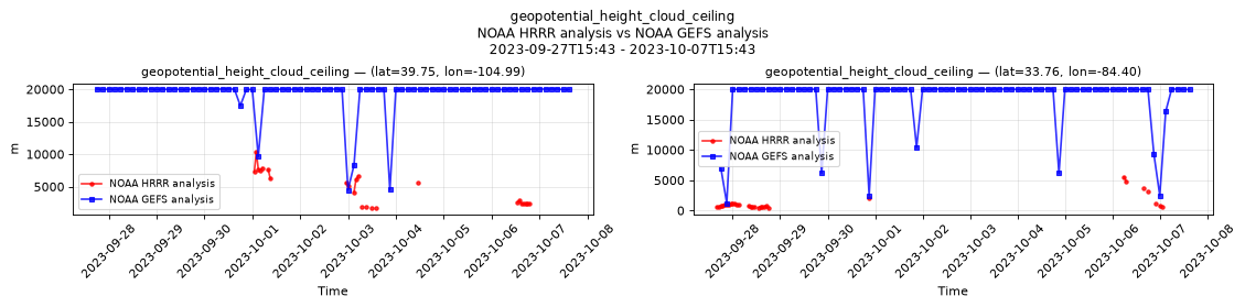
Temporal — 2023-09-27T15:43 - 2023-10-07T15:43
| Source | min | mean | max |
|---|---|---|---|
| P1 Validation | 1688 | 4670 | 1.03e+04 |
| P1 Reference | 4480 | 1.93e+04 | 2.003e+04 |
| P2 Validation | 402 | 1295 | 5504 |
| P2 Reference | 1228 | 1.852e+04 | 2.003e+04 |
Availability — 86515 of 104175 positions complete (incomplete 2014-10-01T00:00 → 2020-11-12T09:00)
percent_frozen_precipitation_surface
Metadata
| Field | Value |
|---|---|
| units | percent |
| long_name | Percent frozen precipitation |
| short_name | cpofp |
| standard_name | n/a |
| step_type | instant |
| comment | NaN where there is no precipitation. |
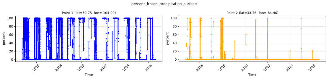
Point time series — 2014-10-01T00:00 - 2026-08-19T14:00
| Point | min | mean | max |
|---|---|---|---|
| P1 | 0 | 46.51 | 100 |
| P2 | 0 | 1.623 | 100 |
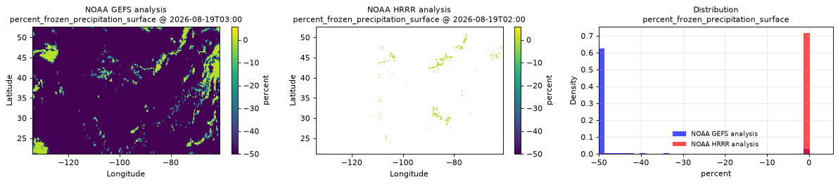
Spatial — 2026-08-19T02:00 (reference at 2026-08-19T03:00)
| Source | min | mean | max |
|---|---|---|---|
| Validation | 0 | 0.0009825 | 5.688 |
| Reference | -50 | -46.05 | -6.109e-06 |
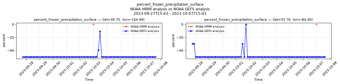
Temporal — 2023-09-27T15:43 - 2023-10-07T15:43
| Source | min | mean | max |
|---|---|---|---|
| P1 Validation | 0 | 0 | 0 |
| P1 Reference | -50 | -49.38 | -10.62 |
| P2 Validation | 0 | 0 | 0 |
| P2 Reference | -50 | -48.62 | -6.109e-06 |
Availability — 86514 of 104175 positions complete (incomplete 2014-10-01T00:00 → 2020-11-12T10:00)
precipitable_water_atmosphere
Metadata
| Field | Value |
|---|---|
| units | kg m-2 |
| long_name | Precipitable water |
| short_name | pwat |
| standard_name | atmosphere_mass_content_of_water_vapor |
| step_type | instant |
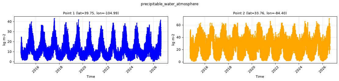
Point time series — 2014-10-01T00:00 - 2026-08-19T14:00
| Point | min | mean | max |
|---|---|---|---|
| P1 | 0.6445 | 11.37 | 43 |
| P2 | 1.242 | 24.87 | 70.5 |
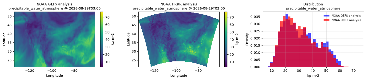
Spatial — 2026-08-19T02:00 (reference at 2026-08-19T03:00)
| Source | min | mean | max |
|---|---|---|---|
| Validation | 3.312 | 30.56 | 77.5 |
| Reference | 7.812 | 31.62 | 62 |
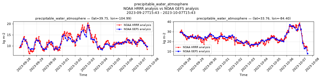
Temporal — 2023-09-27T15:43 - 2023-10-07T15:43
| Source | min | mean | max |
|---|---|---|---|
| P1 Validation | 6.5 | 11.84 | 20.38 |
| P1 Reference | 8.312 | 11.58 | 19.38 |
| P2 Validation | 11.38 | 23.19 | 38.75 |
| P2 Reference | 7.812 | 23.64 | 37 |
Availability — 102108 of 104175 positions complete (incomplete 2014-10-02T12:00 → 2020-11-12T09:00); nulls P1 2067/104175, P2 2067/104175
precipitation_surface
Metadata
| Field | Value |
|---|---|
| units | kg m-2 s-1 |
| long_name | Precipitation rate |
| short_name | prate |
| standard_name | precipitation_flux |
| step_type | avg |
| comment | Average precipitation rate since the previous forecast step. Units equivalent to mm/s. |
Point time series — 2014-10-01T00:00 - 2026-08-19T14:00
| Point | min | mean | max |
|---|---|---|---|
| P1 | 0 | 1.187e-05 | 0.007874 |
| P2 | 0 | 4e-05 | 0.01978 |
Spatial — 2026-08-19T02:00 (reference at 2026-08-19T03:00)
| Source | min | mean | max |
|---|---|---|---|
| Validation | 0 | 1.214e-05 | 0.03125 |
| Reference | 0 | 1.84e-05 | 0.0009232 |
Temporal — 2023-09-27T15:43 - 2023-10-07T15:43
| Source | min | mean | max |
|---|---|---|---|
| P1 Validation | 0 | 5.159e-07 | 6.914e-05 |
| P1 Reference | 0 | 1.748e-06 | 8.345e-05 |
| P2 Validation | 0 | 2.475e-07 | 4.077e-05 |
| P2 Reference | 0 | 1.099e-06 | 4.625e-05 |
Availability — 102116 of 104175 positions complete (incomplete 2014-10-01T00:00 → 2020-11-12T10:00); nulls P1 2059/104175, P2 2059/104175
pressure_reduced_to_mean_sea_level
Metadata
| Field | Value |
|---|---|
| units | Pa |
| long_name | Pressure reduced to MSL |
| short_name | prmsl |
| standard_name | air_pressure_at_mean_sea_level |
| step_type | instant |
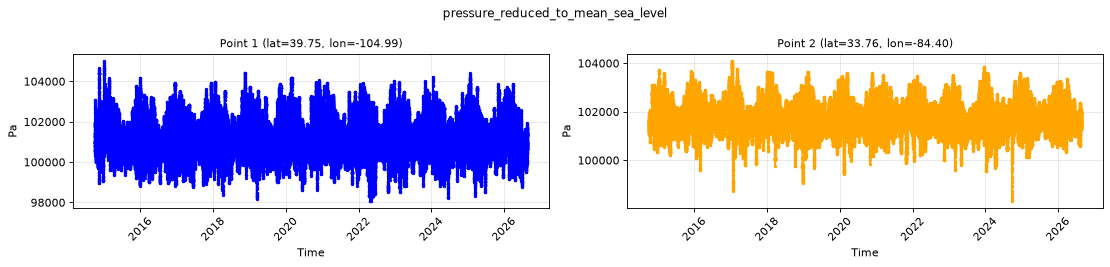
Point time series — 2014-10-01T00:00 - 2026-08-19T14:00
| Point | min | mean | max |
|---|---|---|---|
| P1 | 9.807e+04 | 1.012e+05 | 1.05e+05 |
| P2 | 9.832e+04 | 1.018e+05 | 1.041e+05 |
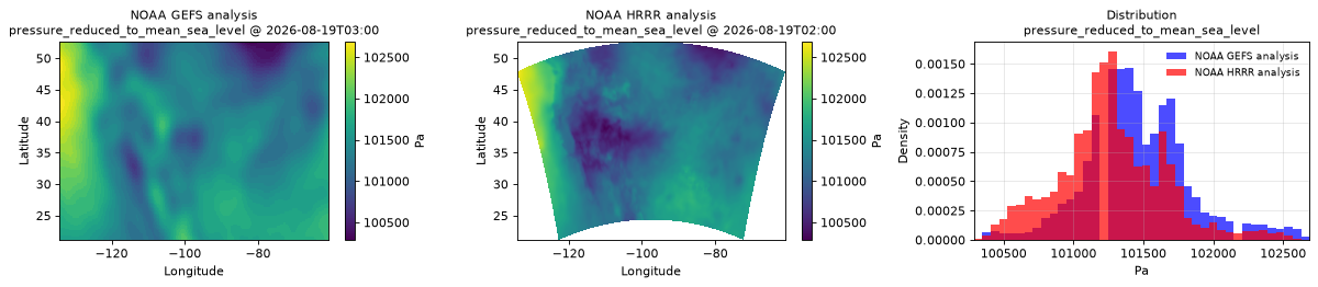
Spatial — 2026-08-19T02:00 (reference at 2026-08-19T03:00)
| Source | min | mean | max |
|---|---|---|---|
| Validation | 1.003e+05 | 1.013e+05 | 1.027e+05 |
| Reference | 1.003e+05 | 1.015e+05 | 1.027e+05 |
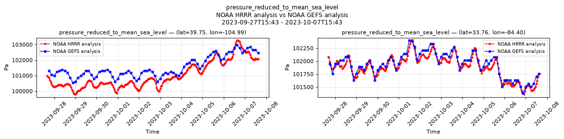
Temporal — 2023-09-27T15:43 - 2023-10-07T15:43
| Source | min | mean | max |
|---|---|---|---|
| P1 Validation | 9.979e+04 | 1.01e+05 | 1.033e+05 |
| P1 Reference | 1.005e+05 | 1.015e+05 | 1.03e+05 |
| P2 Validation | 1.014e+05 | 1.019e+05 | 1.024e+05 |
| P2 Reference | 1.014e+05 | 1.019e+05 | 1.024e+05 |
Availability — 102122 of 104175 positions complete (incomplete 2014-10-02T12:00 → 2020-11-12T09:00); nulls P1 2053/104175, P2 2053/104175
pressure_surface
Metadata
| Field | Value |
|---|---|
| units | Pa |
| long_name | Surface pressure |
| short_name | sp |
| standard_name | surface_air_pressure |
| step_type | instant |
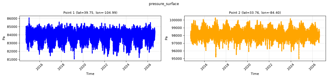
Point time series — 2014-10-01T00:00 - 2026-08-19T14:00
| Point | min | mean | max |
|---|---|---|---|
| P1 | 8.109e+04 | 8.391e+04 | 8.608e+04 |
| P2 | 9.498e+04 | 9.822e+04 | 1.003e+05 |
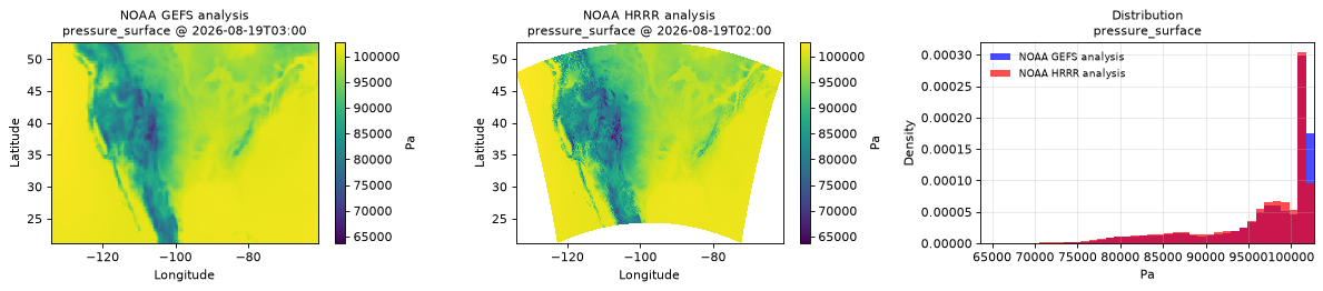
Spatial — 2026-08-19T02:00 (reference at 2026-08-19T03:00)
| Source | min | mean | max |
|---|---|---|---|
| Validation | 6.368e+04 | 9.619e+04 | 1.027e+05 |
| Reference | 6.874e+04 | 9.695e+04 | 1.027e+05 |
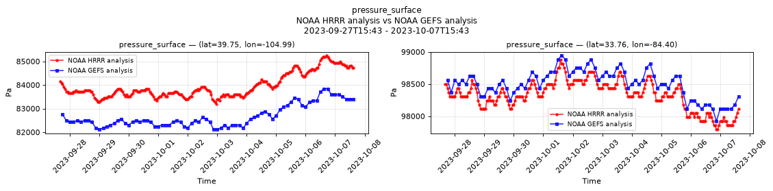
Temporal — 2023-09-27T15:43 - 2023-10-07T15:43
| Source | min | mean | max |
|---|---|---|---|
| P1 Validation | 8.32e+04 | 8.395e+04 | 8.525e+04 |
| P1 Reference | 8.211e+04 | 8.267e+04 | 8.384e+04 |
| P2 Validation | 9.779e+04 | 9.833e+04 | 9.888e+04 |
| P2 Reference | 9.792e+04 | 9.85e+04 | 9.894e+04 |
Availability — 102122 of 104175 positions complete (incomplete 2014-10-02T12:00 → 2020-11-12T09:00); nulls P1 2053/104175, P2 2053/104175
relative_humidity_2m
Metadata
| Field | Value |
|---|---|
| units | percent |
| long_name | 2 metre relative humidity |
| short_name | 2r |
| standard_name | relative_humidity |
| step_type | instant |
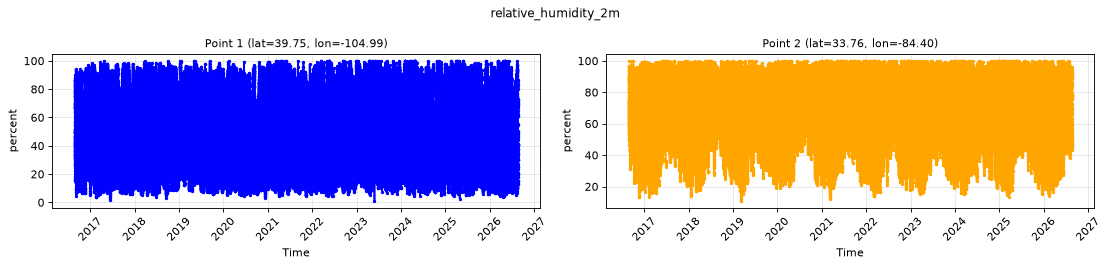
Point time series — 2014-10-01T00:00 - 2026-08-19T14:00
| Point | min | mean | max |
|---|---|---|---|
| P1 | 1 | 47.79 | 100 |
| P2 | 10.81 | 70.5 | 100 |
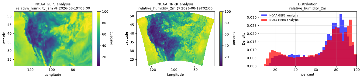
Spatial — 2026-08-19T02:00 (reference at 2026-08-19T03:00)
| Source | min | mean | max |
|---|---|---|---|
| Validation | 4 | 66.25 | 100 |
| Reference | 10.19 | 68.72 | 100 |
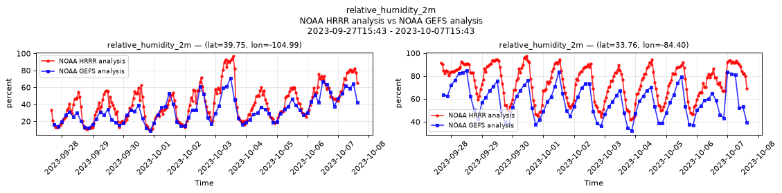
Temporal — 2023-09-27T15:43 - 2023-10-07T15:43
| Source | min | mean | max |
|---|---|---|---|
| P1 Validation | 8.688 | 41.18 | 97 |
| P1 Reference | 9.062 | 33.01 | 71 |
| P2 Validation | 41.5 | 74.51 | 97.5 |
| P2 Reference | 32 | 58.11 | 85 |
Availability — 86515 of 104175 positions complete (incomplete 2014-10-01T00:00 → 2020-11-12T09:00); nulls P1 17660/104175, P2 17660/104175
snow_area_fraction_surface
Metadata
| Field | Value |
|---|---|
| units | 1 |
| long_name | Snow cover |
| short_name | snowc |
| standard_name | surface_snow_area_fraction |
| step_type | instant |
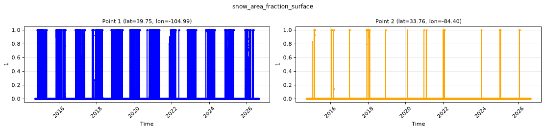
Point time series — 2014-10-01T00:00 - 2026-08-19T14:00
| Point | min | mean | max |
|---|---|---|---|
| P1 | 0 | 0.1104 | 1 |
| P2 | 0 | 0.00391 | 1 |
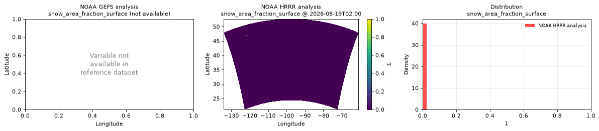
Spatial — 2026-08-19T02:00 (reference not available)
| Source | min | mean | max |
|---|---|---|---|
| Validation | 0 | 5.511e-05 | 1 |
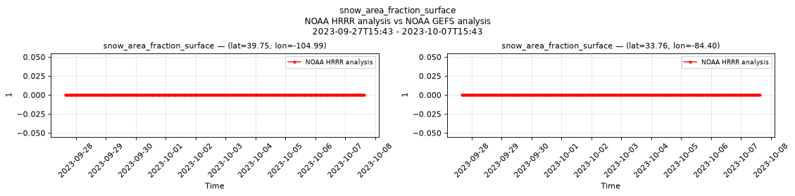
Temporal — 2023-09-27T15:43 - 2023-10-07T15:43
| Source | min | mean | max |
|---|---|---|---|
| P1 Validation | 0 | 0 | 0 |
| P2 Validation | 0 | 0 | 0 |
Availability — 102121 of 104175 positions complete (incomplete 2014-10-02T12:00 → 2020-11-12T09:00); nulls P1 2054/104175, P2 2054/104175
snow_thickness_surface
Metadata
| Field | Value |
|---|---|
| units | m |
| long_name | Snow depth |
| short_name | sde |
| standard_name | surface_snow_thickness |
| step_type | instant |
Point time series — 2014-10-01T00:00 - 2026-08-19T14:00
| Point | min | mean | max |
|---|---|---|---|
| P1 | 0 | 0.004892 | 0.3477 |
| P2 | 0 | 0.0001034 | 0.08984 |
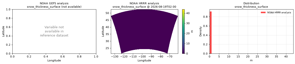
Spatial — 2026-08-19T02:00 (reference not available)
| Source | min | mean | max |
|---|---|---|---|
| Validation | 0 | 0.0002276 | 43.75 |
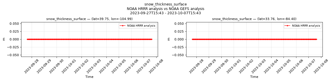
Temporal — 2023-09-27T15:43 - 2023-10-07T15:43
| Source | min | mean | max |
|---|---|---|---|
| P1 Validation | 0 | 0 | 0 |
| P2 Validation | 0 | 0 | 0 |
Availability — 102121 of 104175 positions complete (incomplete 2014-10-02T12:00 → 2020-11-12T09:00); nulls P1 2054/104175, P2 2054/104175
snow_water_equivalent_surface
Metadata
| Field | Value |
|---|---|
| units | m |
| long_name | Snow depth water equivalent |
| short_name | sd |
| standard_name | lwe_thickness_of_surface_snow_amount |
| step_type | instant |
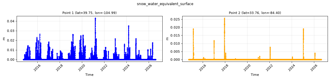
Point time series — 2014-10-01T00:00 - 2026-08-19T14:00
| Point | min | mean | max |
|---|---|---|---|
| P1 | 0 | 0.0005625 | 0.04321 |
| P2 | 0 | 3.082e-05 | 0.02576 |
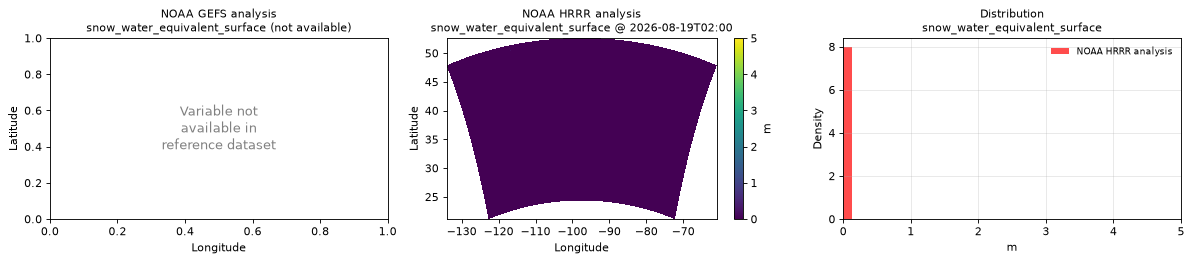
Spatial — 2026-08-19T02:00 (reference not available)
| Source | min | mean | max |
|---|---|---|---|
| Validation | 0 | 5.594e-05 | 5 |
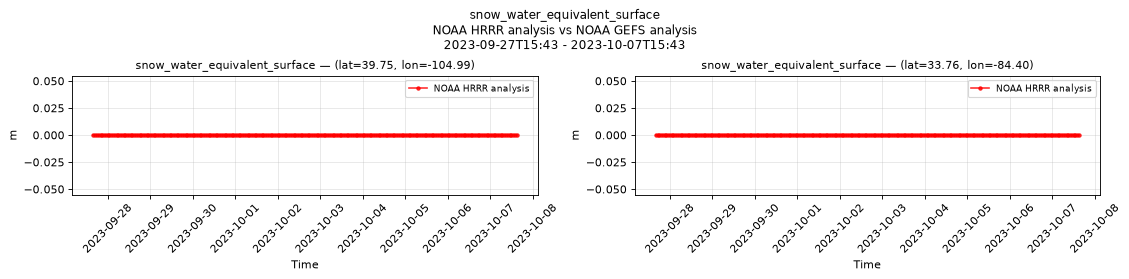
Temporal — 2023-09-27T15:43 - 2023-10-07T15:43
| Source | min | mean | max |
|---|---|---|---|
| P1 Validation | 0 | 0 | 0 |
| P2 Validation | 0 | 0 | 0 |
Availability — 102121 of 104175 positions complete (incomplete 2014-10-02T12:00 → 2020-11-12T09:00); nulls P1 2054/104175, P2 2054/104175
snowfall_surface
Metadata
| Field | Value |
|---|---|
| units | m s-1 |
| long_name | Total snowfall rate |
| short_name | tsrate |
| standard_name | n/a |
| step_type | avg |
| comment | Average snowfall rate since the previous forecast step. |
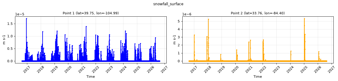
Point time series — 2014-10-01T00:00 - 2026-08-19T14:00
| Point | min | mean | max |
|---|---|---|---|
| P1 | 0 | 4.646e-08 | 1.705e-05 |
| P2 | 0 | 1.753e-09 | 5.335e-06 |
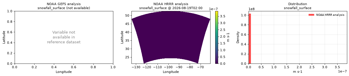
Spatial — 2026-08-19T02:00 (reference not available)
| Source | min | mean | max |
|---|---|---|---|
| Validation | 0 | 1.76e-12 | 3.874e-07 |
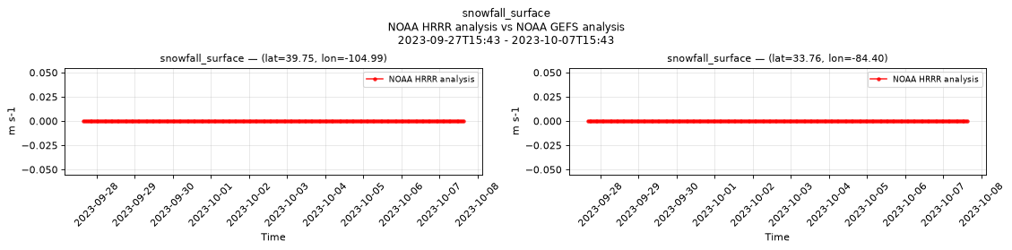
Temporal — 2023-09-27T15:43 - 2023-10-07T15:43
| Source | min | mean | max |
|---|---|---|---|
| P1 Validation | 0 | 0 | 0 |
| P2 Validation | 0 | 0 | 0 |
Availability — 86514 of 104175 positions complete (incomplete 2014-10-01T00:00 → 2020-11-12T10:00); nulls P1 17661/104175, P2 17661/104175
temperature_2m
Metadata
| Field | Value |
|---|---|
| units | degree_Celsius |
| long_name | 2 metre temperature |
| short_name | 2t |
| standard_name | air_temperature |
| step_type | instant |
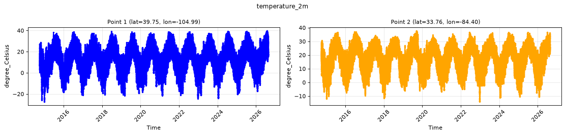
Point time series — 2014-10-01T00:00 - 2026-08-19T14:00
| Point | min | mean | max |
|---|---|---|---|
| P1 | -27.25 | 11.42 | 39.75 |
| P2 | -14.06 | 17.29 | 37.75 |
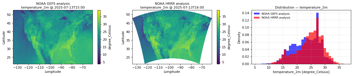
Spatial — 2026-08-19T02:00 (reference at 2026-08-19T03:00)
| Source | min | mean | max |
|---|---|---|---|
| Validation | 2.438 | 24.04 | 46.75 |
| Reference | 6.906 | 22.42 | 41.25 |
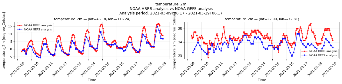
Temporal — 2023-09-27T15:43 - 2023-10-07T15:43
| Source | min | mean | max |
|---|---|---|---|
| P1 Validation | 1.555 | 16.75 | 31.62 |
| P1 Reference | 5.969 | 17.59 | 29.75 |
| P2 Validation | 12.5 | 20.85 | 29.12 |
| P2 Reference | 13.06 | 22.11 | 31 |
Availability — 102121 of 104175 positions complete (incomplete 2014-10-02T12:00 → 2020-11-12T09:00); nulls P1 2054/104175, P2 2054/104175
total_cloud_cover_atmosphere
Metadata
| Field | Value |
|---|---|
| units | percent |
| long_name | Total cloud cover |
| short_name | tcc |
| standard_name | cloud_area_fraction |
| step_type | instant |
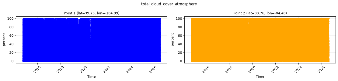
Point time series — 2014-10-01T00:00 - 2026-08-19T14:00
| Point | min | mean | max |
|---|---|---|---|
| P1 | 0 | 33.46 | 100 |
| P2 | 0 | 39.47 | 100 |
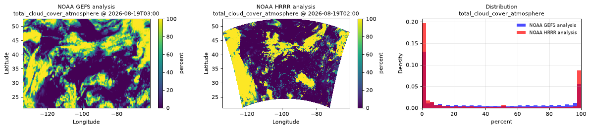
Spatial — 2026-08-19T02:00 (reference at 2026-08-19T03:00)
| Source | min | mean | max |
|---|---|---|---|
| Validation | 0 | 31.23 | 100 |
| Reference | 0 | 39.59 | 100 |
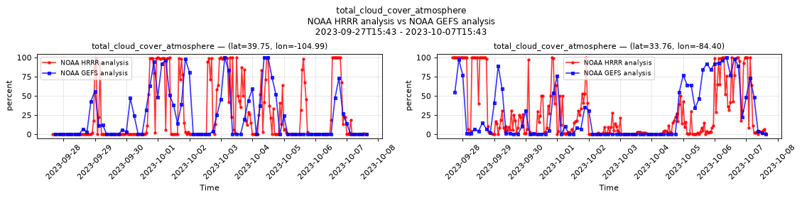
Temporal — 2023-09-27T15:43 - 2023-10-07T15:43
| Source | min | mean | max |
|---|---|---|---|
| P1 Validation | 0 | 25.2 | 100 |
| P1 Reference | 0 | 23.58 | 100 |
| P2 Validation | 0 | 27.66 | 100 |
| P2 Reference | 0 | 27.09 | 100 |
Availability — 102108 of 104175 positions complete (incomplete 2014-10-02T12:00 → 2020-11-12T09:00); nulls P1 2067/104175, P2 2067/104175
visible_beam_downward_solar_flux_surface
Metadata
| Field | Value |
|---|---|
| units | W m-2 |
| long_name | Visible Beam Downward Solar Flux |
| short_name | vbdsf |
| standard_name | n/a |
| step_type | instant |
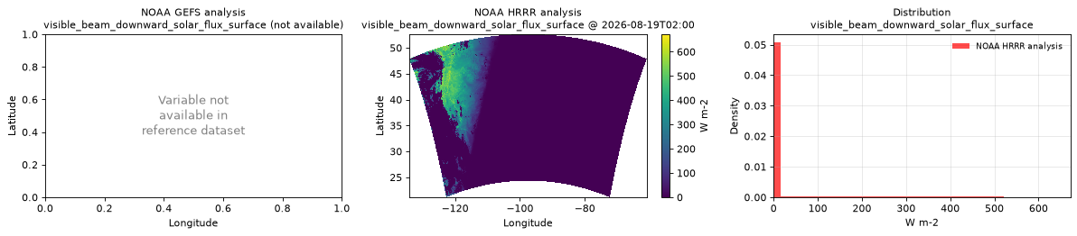
| comment | Direct normal irradiance — the flux perpendicular to the solar beam, so it exceeds the horizontal downward shortwave flux when the sun is low. Values inflate without bound in a narrow band of grid cells at sunrise, reaching 10000. Mask values > 1361, the solar constant. |
Point time series — 2014-10-01T00:00 - 2026-08-19T14:00
| Point | min | mean | max |
|---|---|---|---|
| P1 | 0 | 273.3 | 6368 |
| P2 | 0 | 227 | 1624 |
Spatial — 2026-08-19T02:00 (reference not available)
| Source | min | mean | max |
|---|---|---|---|
| Validation | 0 | 38.35 | 672 |
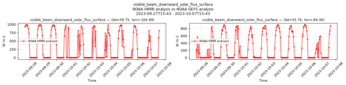
Temporal — 2023-09-27T15:43 - 2023-10-07T15:43
| Source | min | mean | max |
|---|---|---|---|
| P1 Validation | 0 | 283.3 | 992 |
| P2 Validation | 0 | 257.6 | 908 |
Availability — 86515 of 104175 positions complete (incomplete 2014-10-01T00:00 → 2020-11-12T09:00); nulls P1 17660/104175, P2 17660/104175
wind_gust_surface
Metadata
| Field | Value |
|---|---|
| units | m s-1 |
| long_name | Wind speed (gust) |
| short_name | gust |
| standard_name | wind_speed_of_gust |
| step_type | instant |
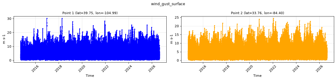
Point time series — 2014-10-01T00:00 - 2026-08-19T14:00
| Point | min | mean | max |
|---|---|---|---|
| P1 | 0.03857 | 4.534 | 30.25 |
| P2 | 0.04834 | 5.105 | 24.5 |
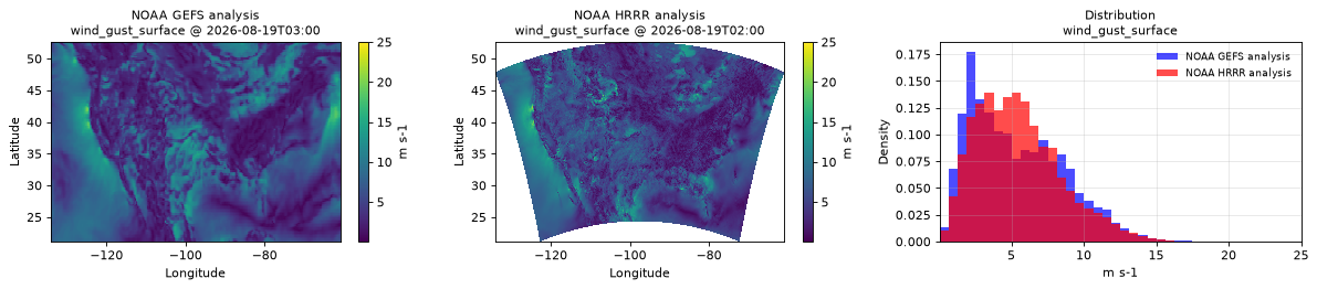
Spatial — 2026-08-19T02:00 (reference at 2026-08-19T03:00)
| Source | min | mean | max |
|---|---|---|---|
| Validation | 0.04102 | 5.495 | 25 |
| Reference | 0.1211 | 5.42 | 19.5 |
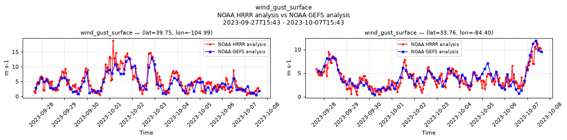
Temporal — 2023-09-27T15:43 - 2023-10-07T15:43
| Source | min | mean | max |
|---|---|---|---|
| P1 Validation | 0.4727 | 5.052 | 18.75 |
| P1 Reference | 0.5234 | 4.425 | 12.75 |
| P2 Validation | 0.3672 | 3.978 | 11.62 |
| P2 Reference | 0.3984 | 4.163 | 11.88 |
Availability — 102123 of 104175 positions complete (incomplete 2014-10-02T12:00 → 2020-11-12T09:00); nulls P1 2052/104175, P2 2052/104175
wind_u_10m
Metadata
| Field | Value |
|---|---|
| units | m s-1 |
| long_name | 10 metre U wind component |
| short_name | 10u |
| standard_name | x_wind |
| step_type | instant |
| comment | Velocity along the model grid's x dimension, not eastward velocity. |
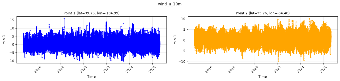
Point time series — 2014-10-01T00:00 - 2026-08-19T14:00
| Point | min | mean | max |
|---|---|---|---|
| P1 | -10.12 | -0.1008 | 15.88 |
| P2 | -9.75 | 0.2962 | 10.12 |
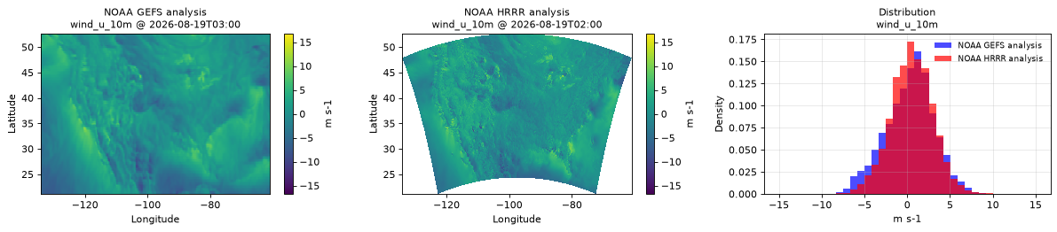
Spatial — 2026-08-19T02:00 (reference at 2026-08-19T03:00)
| Source | min | mean | max |
|---|---|---|---|
| Validation | -16.75 | 0.5125 | 16.75 |
| Reference | -9.375 | 0.2729 | 10.62 |
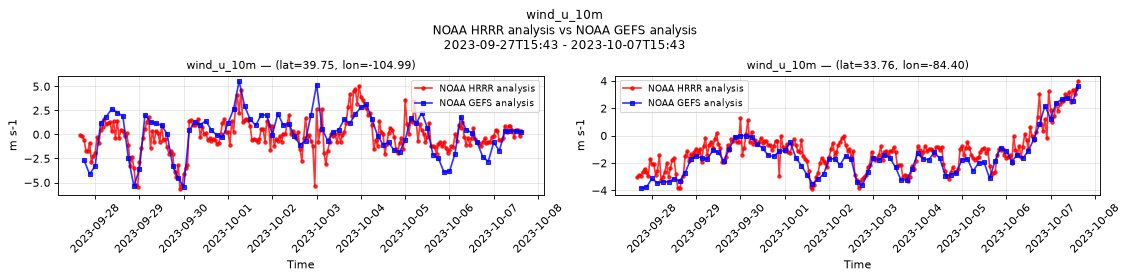
Temporal — 2023-09-27T15:43 - 2023-10-07T15:43
| Source | min | mean | max |
|---|---|---|---|
| P1 Validation | -5.688 | -0.1115 | 5.062 |
| P1 Reference | -5.5 | 0.0905 | 5.562 |
| P2 Validation | -3.906 | -1.128 | 4 |
| P2 Reference | -3.844 | -1.532 | 3.625 |
Availability — 102121 of 104175 positions complete (incomplete 2014-10-02T12:00 → 2020-11-12T09:00); nulls P1 2054/104175, P2 2054/104175
wind_u_80m
Metadata
| Field | Value |
|---|---|
| units | m s-1 |
| long_name | 80 metre U wind component |
| short_name | 80u |
| standard_name | x_wind |
| step_type | instant |
| comment | Velocity along the model grid's x dimension, not eastward velocity. |
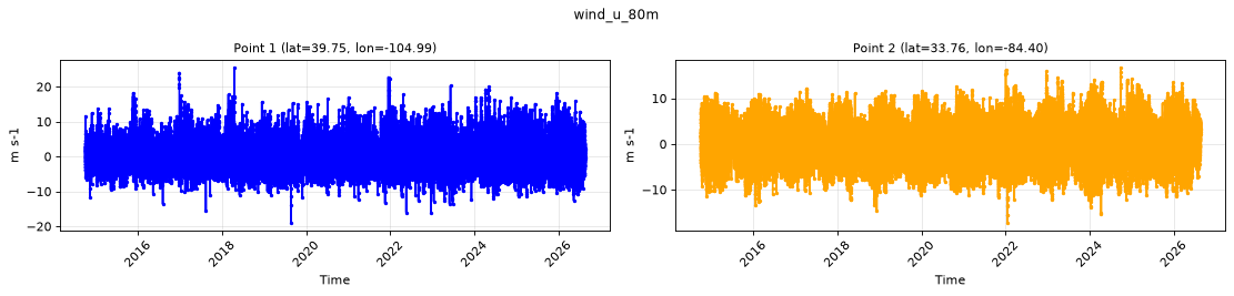
Point time series — 2014-10-01T00:00 - 2026-08-19T14:00
| Point | min | mean | max |
|---|---|---|---|
| P1 | -19 | 0.2222 | 25.5 |
| P2 | -17.25 | 0.5581 | 16.75 |
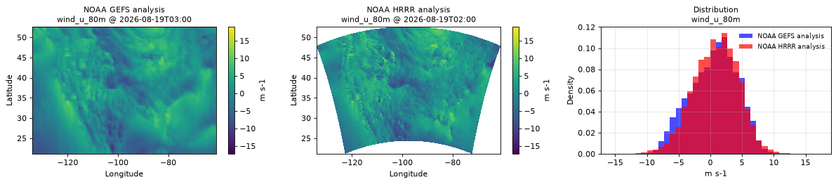
Spatial — 2026-08-19T02:00 (reference at 2026-08-19T03:00)
| Source | min | mean | max |
|---|---|---|---|
| Validation | -17.25 | 0.8441 | 19 |
| Reference | -12 | 0.5386 | 11.88 |
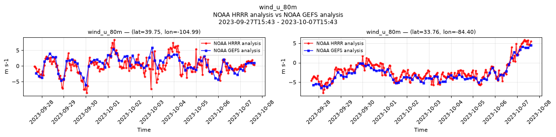
Temporal — 2023-09-27T15:43 - 2023-10-07T15:43
| Source | min | mean | max |
|---|---|---|---|
| P1 Validation | -8.625 | 0.07054 | 8.375 |
| P1 Reference | -6.125 | 0.5761 | 5.875 |
| P2 Validation | -7.75 | -2.219 | 5.875 |
| P2 Reference | -6.438 | -2.86 | 4.438 |
Availability — 102122 of 104175 positions complete (incomplete 2014-10-02T12:00 → 2020-11-12T09:00); nulls P1 2053/104175, P2 2053/104175
wind_v_10m
Metadata
| Field | Value |
|---|---|
| units | m s-1 |
| long_name | 10 metre V wind component |
| short_name | 10v |
| standard_name | y_wind |
| step_type | instant |
| comment | Velocity along the model grid's y dimension, not northward velocity. |
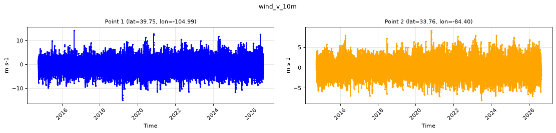
Point time series — 2014-10-01T00:00 - 2026-08-19T14:00
| Point | min | mean | max |
|---|---|---|---|
| P1 | -15 | 0.07656 | 14.25 |
| P2 | -8 | 0.01887 | 9.125 |
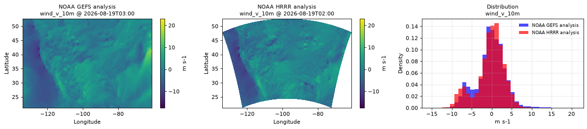
Spatial — 2026-08-19T02:00 (reference at 2026-08-19T03:00)
| Source | min | mean | max |
|---|---|---|---|
| Validation | -17.5 | -0.4393 | 23 |
| Reference | -14 | -0.2854 | 15.62 |
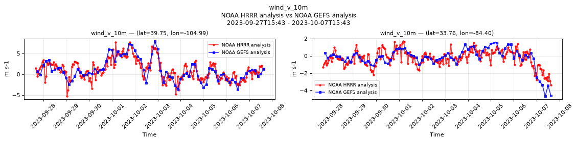
Temporal — 2023-09-27T15:43 - 2023-10-07T15:43
| Source | min | mean | max |
|---|---|---|---|
| P1 Validation | -5.312 | 1.049 | 7.75 |
| P1 Reference | -3.75 | 1.011 | 7.938 |
| P2 Validation | -3.375 | -0.2543 | 1.688 |
| P2 Reference | -4.688 | -0.2054 | 1.531 |
Availability — 102121 of 104175 positions complete (incomplete 2014-10-02T12:00 → 2020-11-12T09:00); nulls P1 2054/104175, P2 2054/104175
wind_v_80m
Metadata
| Field | Value |
|---|---|
| units | m s-1 |
| long_name | 80 metre V wind component |
| short_name | 80v |
| standard_name | y_wind |
| step_type | instant |
| comment | Velocity along the model grid's y dimension, not northward velocity. |
Point time series — 2014-10-01T00:00 - 2026-08-19T14:00
| Point | min | mean | max |
|---|---|---|---|
| P1 | -21.75 | 0.1903 | 22.5 |
| P2 | -14.12 | 0.07285 | 16.25 |
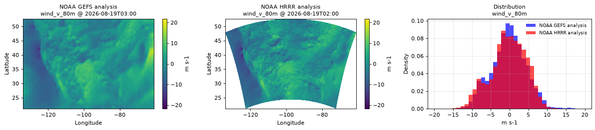
Spatial — 2026-08-19T02:00 (reference at 2026-08-19T03:00)
| Source | min | mean | max |
|---|---|---|---|
| Validation | -21.75 | -0.3152 | 21.75 |
| Reference | -16.75 | -0.2171 | 17.75 |
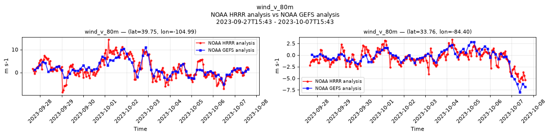
Temporal — 2023-09-27T15:43 - 2023-10-07T15:43
| Source | min | mean | max |
|---|---|---|---|
| P1 Validation | -8.625 | 1.644 | 14.38 |
| P1 Reference | -5.125 | 1.711 | 10.88 |
| P2 Validation | -5.75 | -0.5919 | 3.344 |
| P2 Reference | -8 | -0.472 | 2.781 |
Availability — 102122 of 104175 positions complete (incomplete 2014-10-02T12:00 → 2020-11-12T09:00); nulls P1 2053/104175, P2 2053/104175