NOAA HRRR forecast, 48 hour validation report
This dataset validation report plots a sample of values from the NOAA HRRR forecast, 48 hour dataset over time and across space, comparing where possible to a previously validated reference dataset. It also reports the quantity of unavailable values and their associated timestamps. These analyses are one layer of a multi-layered dataset validation process we perform at dynamical.org and also provide users a preview of the dataset contents.
Report generation start time: 2026-07-23T19:58:32 UTC
Summary
This dataset has been reviewed and is ready for use. All 26 variables were checked across spatial, temporal, and full-archive plots and statistics: the grid geometry, units, and physical value ranges are correct; values are consistent with an independent reference dataset (NOAA GEFS analysis) wherever an equivalent variable exists; and no unit changes, discontinuities, or processing artifacts were found across the 2018–2026 archive. One thing to know before relying on early forecasts: initializations before December 3, 2020 extend to 36 hours rather than 48, because the upstream HRRR model only began producing 48-hour forecasts with HRRRv4 (see Review notes below).
What looks good
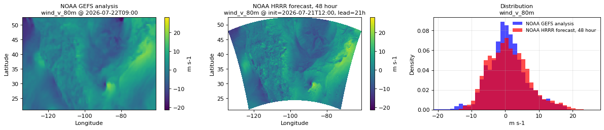
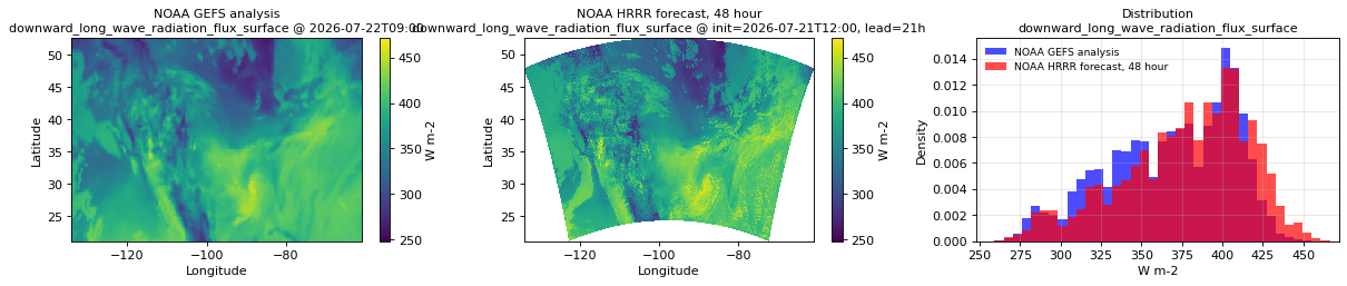
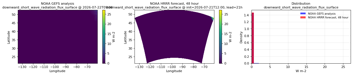
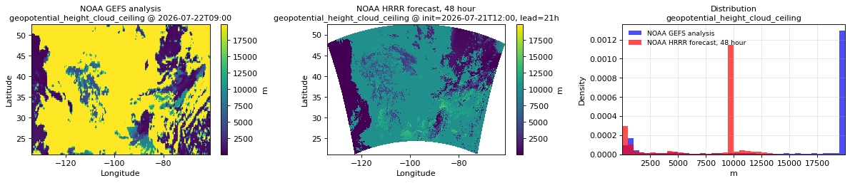
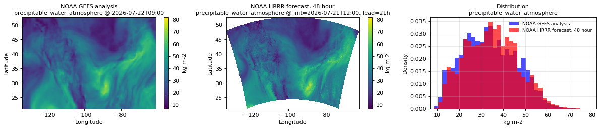
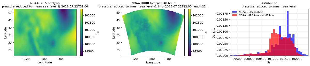
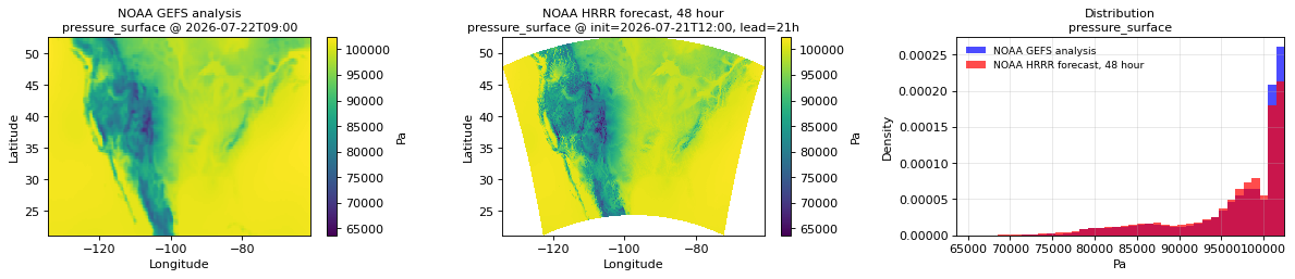
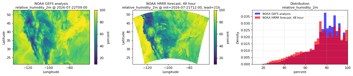
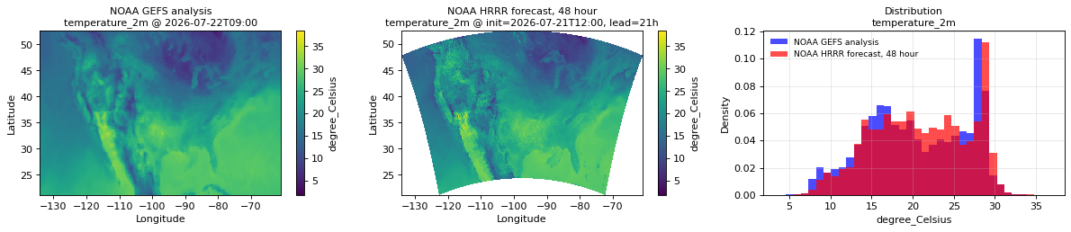
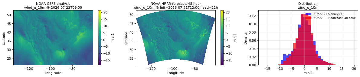
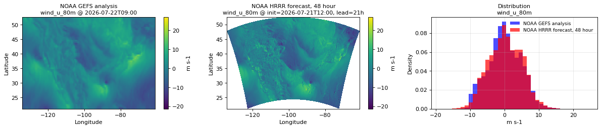
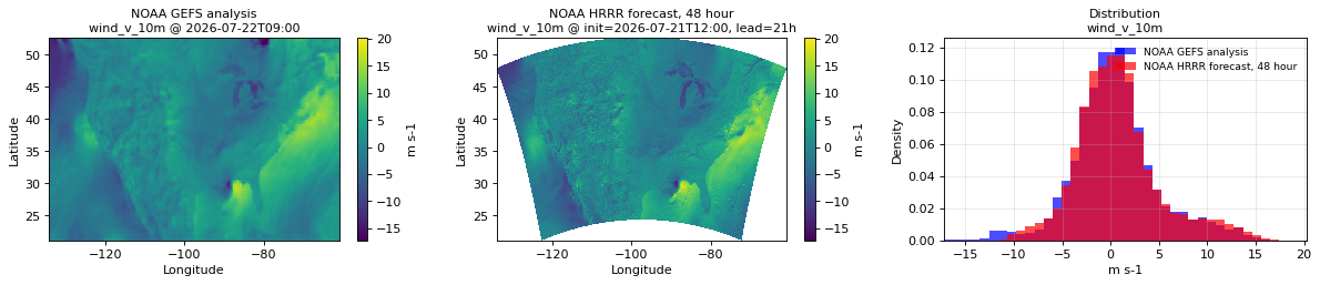
- Geometry, units, and values are correct for all 26 variables. Every map renders the continental-US Lambert-conformal grid correctly; units are as documented (temperatures °C, pressures Pa, radiation W m⁻², reflectivity dBZ, precipitation rate kg m⁻² s⁻¹); value distributions overlap the GEFS reference where a comparison exists, with the sharper extremes expected of a 3 km model versus a ~25 km analysis.
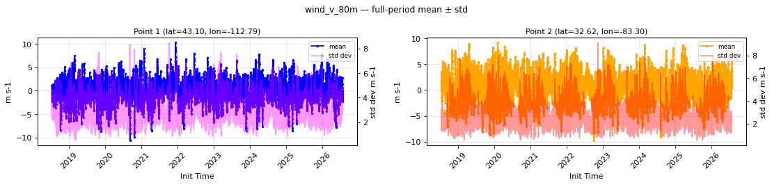
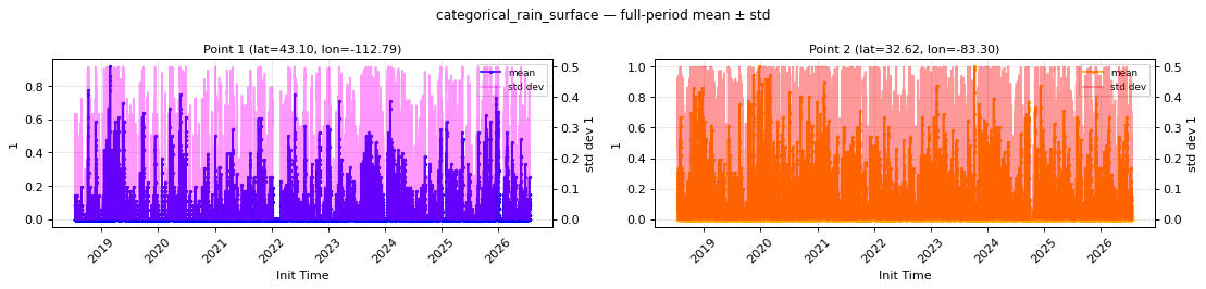
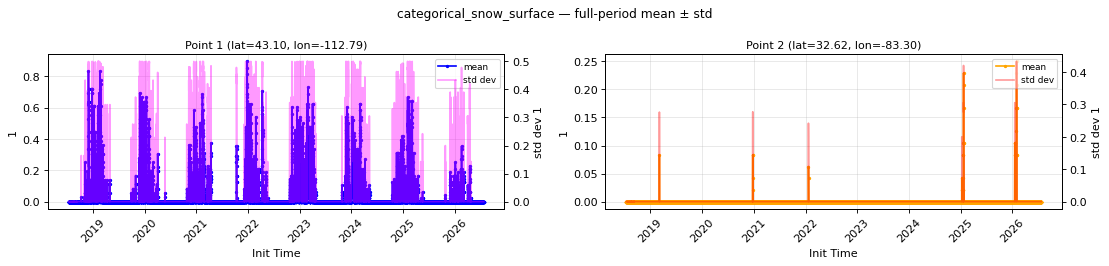
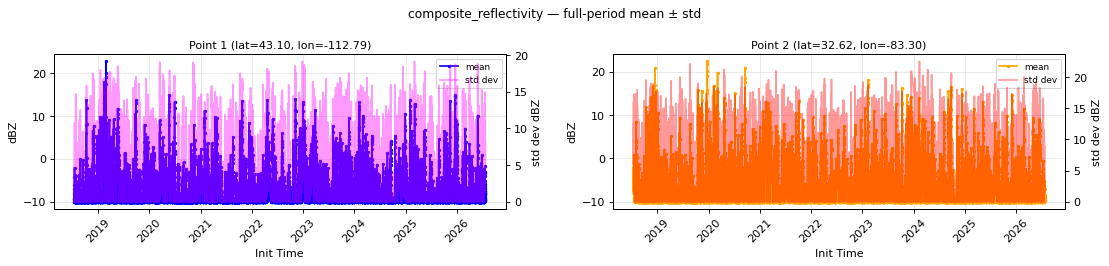
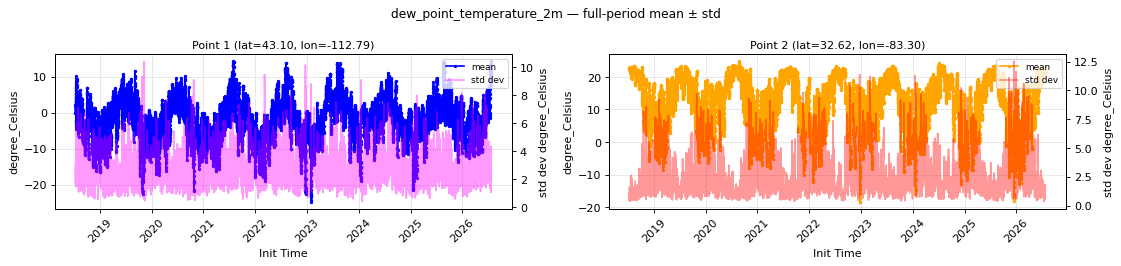
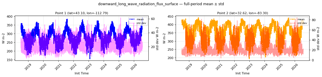
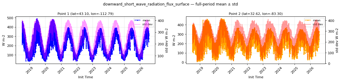
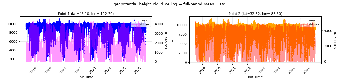
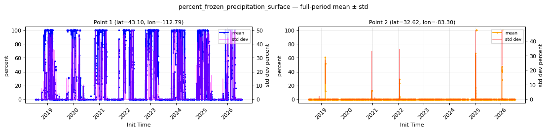
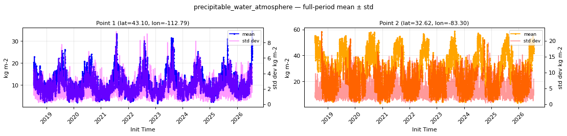
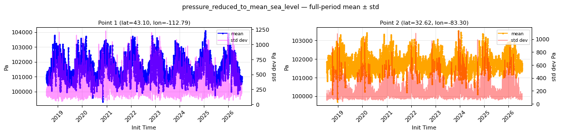
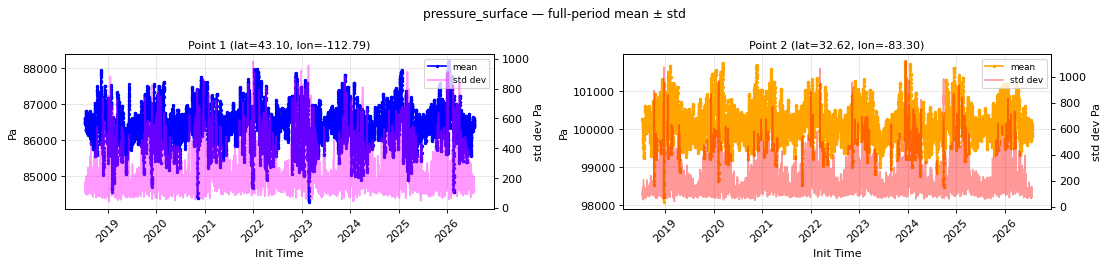
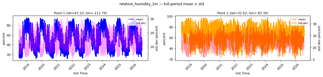
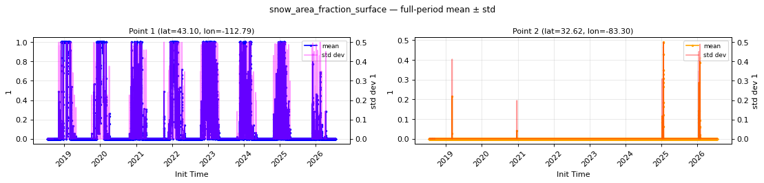
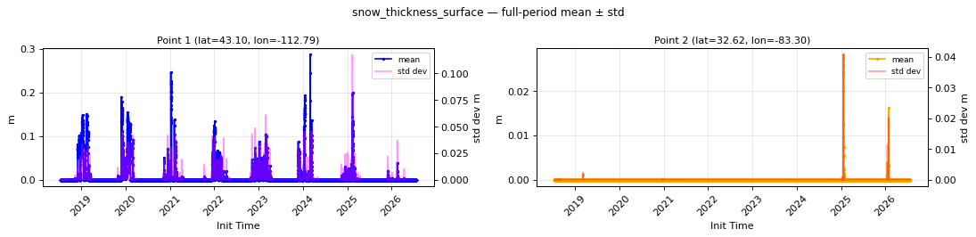
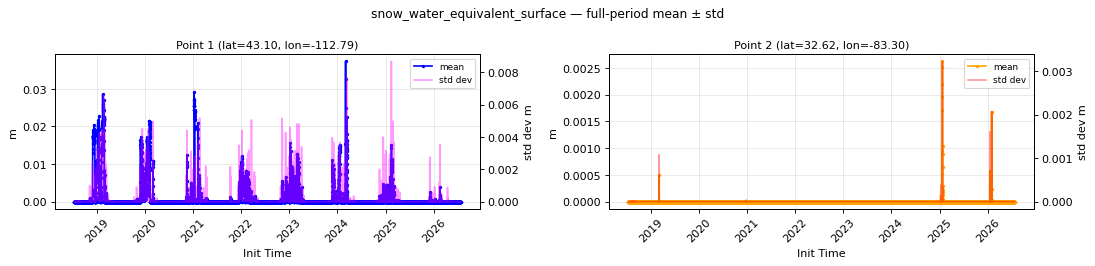
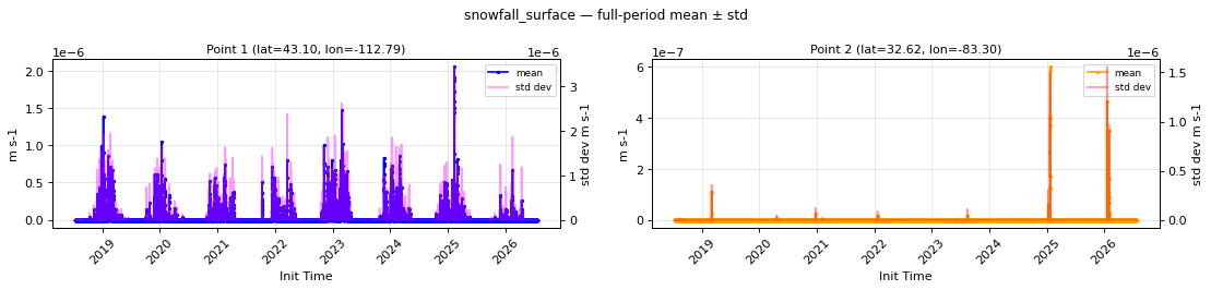
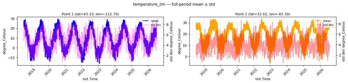
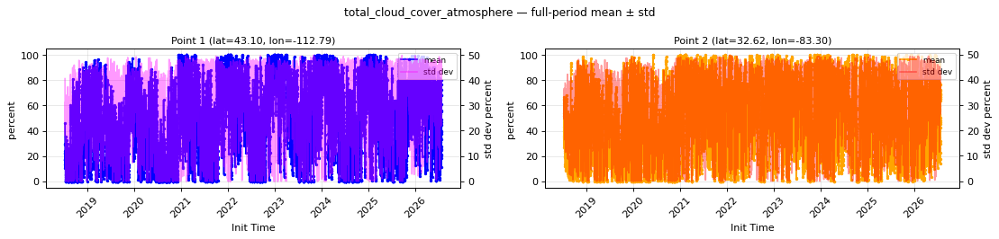
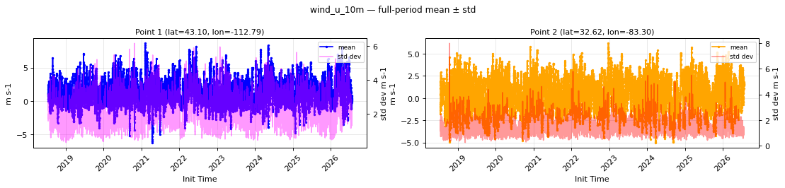
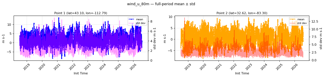
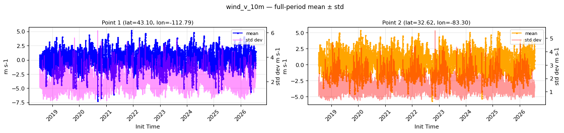
- The archive is internally consistent across its full 2018–2026 span. Full-period mean and spread series show clean seasonal and diurnal cycles with no step changes at HRRR model-version boundaries. Physical relationships hold throughout: dew point never exceeds temperature, 80 m winds are stronger than 10 m winds with matching patterns, radiation and cloud cover vary together, and the snow variables share a coherent winter-peak/summer-zero cycle (including a coordinated signal for the January 2025 Gulf Coast snowstorm).
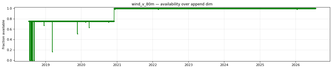
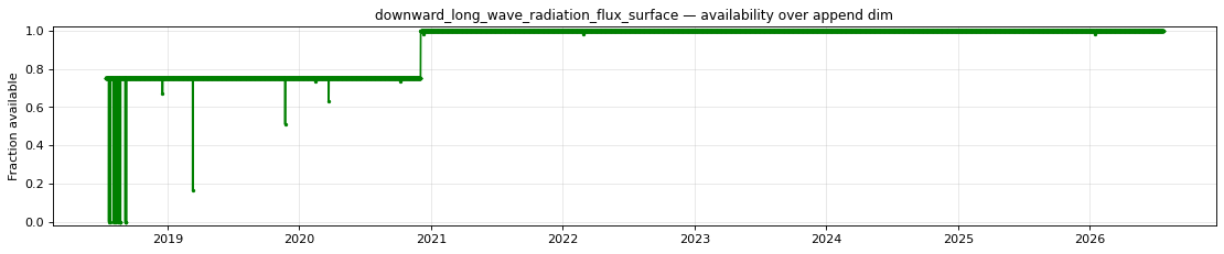
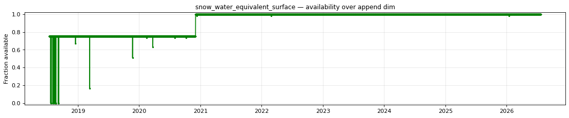
- Availability is fully accounted for. Every expected forecast hour in the archive is present except those confirmed missing from NOAA's upstream archive itself (detailed below).
Review notes
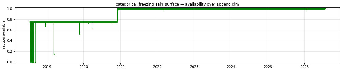
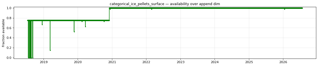
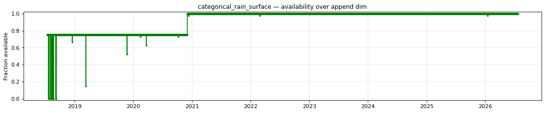
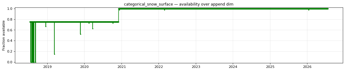
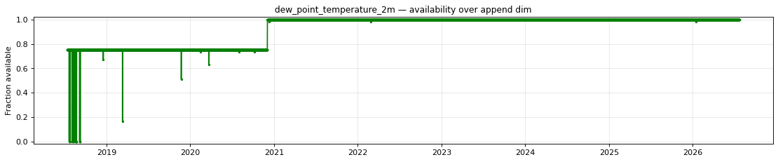
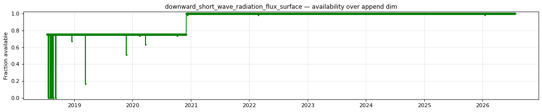
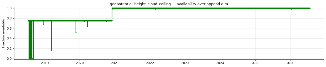
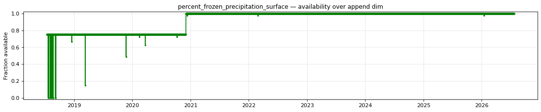
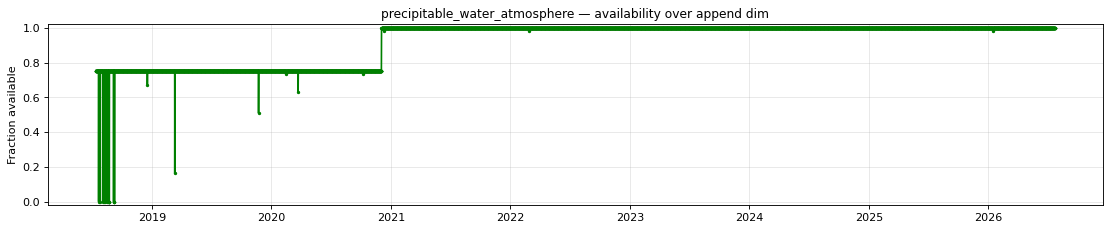
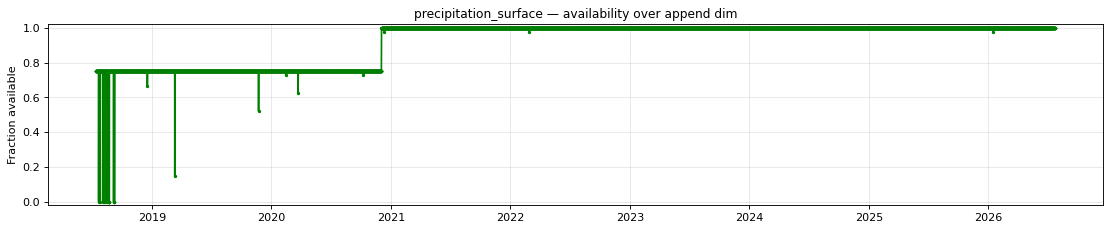
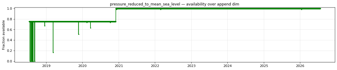
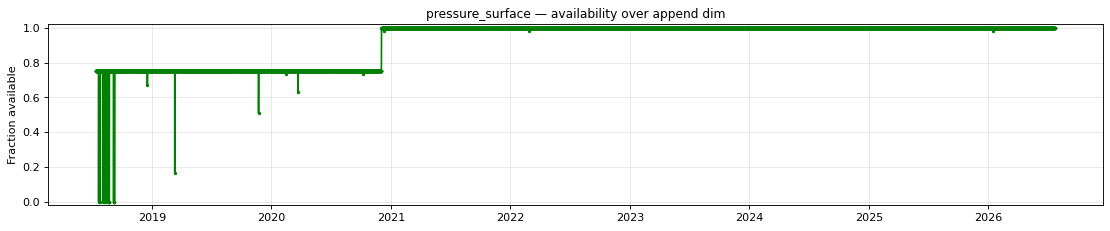
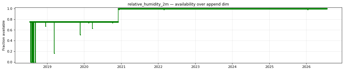
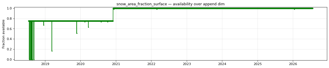
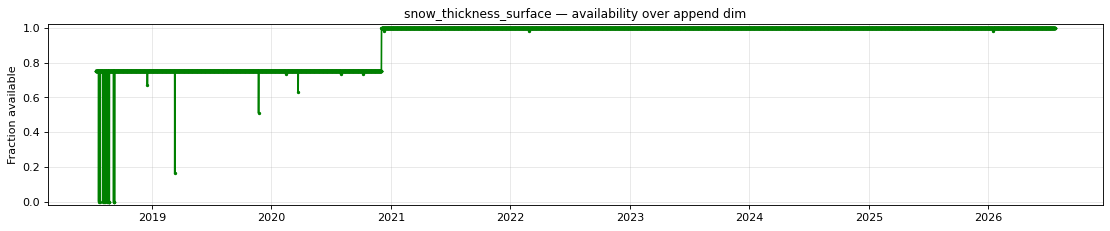
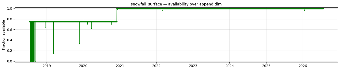
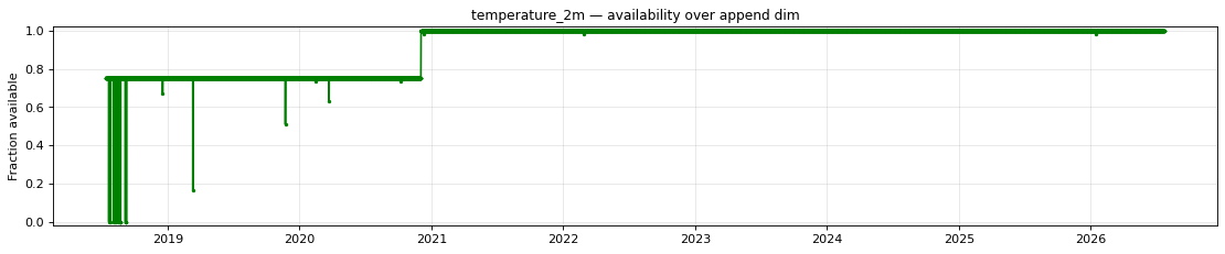
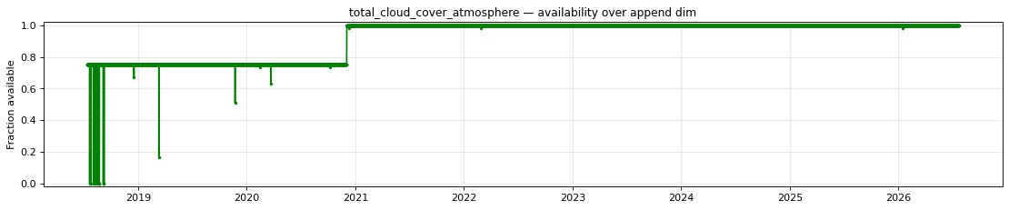
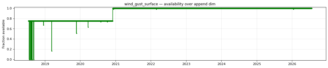
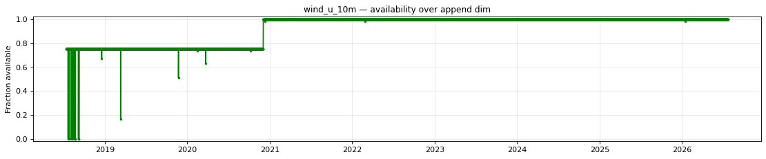
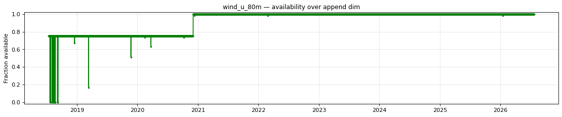
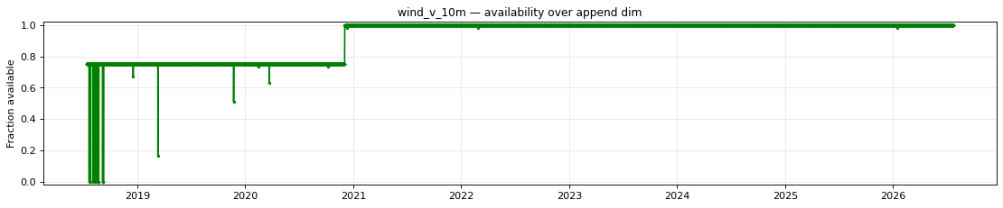
- Forecasts initialized before December 3, 2020 extend to 36 hours only; lead times 37–48 are absent. NOAA extended the 00/06/12/18 UTC HRRR runs from 36-hour to 48-hour forecasts with the HRRRv4 model upgrade. This accounts for essentially all of the "incomplete" fraction shown in the availability table (every initialization from 2018-07-13 through 2020-12-02). This data was never produced upstream and cannot be backfilled.
- The 10 and 80 metre wind components follow the model grid's axes, not east and north. The HRRR runs on a Lambert-conformal grid and its source files resolve the u and v components to that grid, so u is not eastward velocity and v is not northward velocity. They are equivalent to eastward and northward winds along the centre of the model's domain and become offset by up to 22.8 degrees at its eastern and western edges.
- Three individual forecast hours are missing because the source files are absent from NOAA's archive: the 48-hour forecast from 2020-12-11 18:00 UTC, the 12-hour forecast from 2022-02-26 18:00 UTC, and the 45-hour forecast from 2026-01-14 18:00 UTC. Each corresponding upstream file was verified missing (HTTP 404) from the NOAA HRRR archive on AWS; these gaps are not recoverable.
Datasets
| Role | Name | ID | Version | URL |
|---|---|---|---|---|
| Validation | NOAA HRRR forecast, 48 hour | noaa-hrrr-forecast-48-hour |
v0.1.0 |
s3://us-west-2.opendata.source.coop/dynamical/noaa-hrrr-forecast-48-hour/v0.1.0.zarr |
| Reference | NOAA GEFS analysis | noaa-gefs-analysis |
0.1.2 |
s3://dynamical-noaa-gefs/noaa-gefs-analysis/v0.1.2.icechunk/ |
Run parameters
| Parameter | Value |
|---|---|
| Validation dataset type | forecast |
| Validation time range | init_time 2018-07-13T12:00 → 2026-07-23T18:00 |
| Reference time range | time 2000-01-01T00:00 → 2026-07-23T12:00 |
| Point 1 | lat=43.0951, lon=-112.7851 |
| Point 2 | lat=32.6179, lon=-83.3007 |
| Spatial comparison time | init=2026-07-21T12:00, lead=21h (reference at 2026-07-22T09:00) |
| Timeseries period | init=2019-07-05T00:00 |
Availability
The plot below shows the availability of each variable over time — light red marks unavailable data, dark green marks present data.
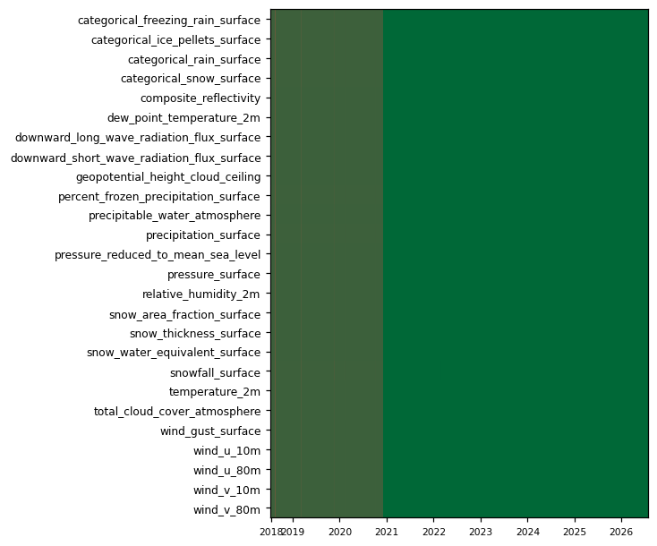
| Variable | Complete positions | Incomplete % | First incomplete | Last incomplete |
|---|---|---|---|---|
categorical_freezing_rain_surface |
8235/11730 | 29.80% | 2018-07-13T12:00 | 2026-01-14T18:00 |
categorical_ice_pellets_surface |
8235/11730 | 29.80% | 2018-07-13T12:00 | 2026-01-14T18:00 |
categorical_rain_surface |
8235/11730 | 29.80% | 2018-07-13T12:00 | 2026-01-14T18:00 |
categorical_snow_surface |
8235/11730 | 29.80% | 2018-07-13T12:00 | 2026-01-14T18:00 |
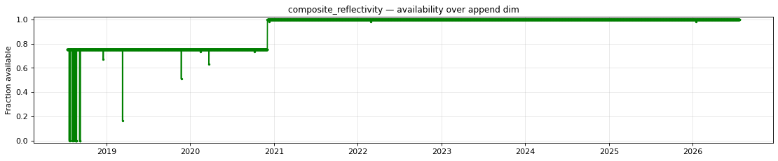
composite_reflectivity |
8235/11730 | 29.80% | 2018-07-13T12:00 | 2026-01-14T18:00 |
dew_point_temperature_2m |
8235/11730 | 29.80% | 2018-07-13T12:00 | 2026-01-14T18:00 |
downward_long_wave_radiation_flux_surface |
8235/11730 | 29.80% | 2018-07-13T12:00 | 2026-01-14T18:00 |
downward_short_wave_radiation_flux_surface |
8235/11730 | 29.80% | 2018-07-13T12:00 | 2026-01-14T18:00 |
geopotential_height_cloud_ceiling |
8235/11730 | 29.80% | 2018-07-13T12:00 | 2026-01-14T18:00 |
percent_frozen_precipitation_surface |
8235/11730 | 29.80% | 2018-07-13T12:00 | 2026-01-14T18:00 |
precipitable_water_atmosphere |
8235/11730 | 29.80% | 2018-07-13T12:00 | 2026-01-14T18:00 |
precipitation_surface |
8235/11730 | 29.80% | 2018-07-13T12:00 | 2026-01-14T18:00 |
pressure_reduced_to_mean_sea_level |
8235/11730 | 29.80% | 2018-07-13T12:00 | 2026-01-14T18:00 |
pressure_surface |
8235/11730 | 29.80% | 2018-07-13T12:00 | 2026-01-14T18:00 |
relative_humidity_2m |
8235/11730 | 29.80% | 2018-07-13T12:00 | 2026-01-14T18:00 |
snow_area_fraction_surface |
8235/11730 | 29.80% | 2018-07-13T12:00 | 2026-01-14T18:00 |
snow_thickness_surface |
8235/11730 | 29.80% | 2018-07-13T12:00 | 2026-01-14T18:00 |
snow_water_equivalent_surface |
8235/11730 | 29.80% | 2018-07-13T12:00 | 2026-01-14T18:00 |
snowfall_surface |
8235/11730 | 29.80% | 2018-07-13T12:00 | 2026-01-14T18:00 |
temperature_2m |
8235/11730 | 29.80% | 2018-07-13T12:00 | 2026-01-14T18:00 |
total_cloud_cover_atmosphere |
8235/11730 | 29.80% | 2018-07-13T12:00 | 2026-01-14T18:00 |
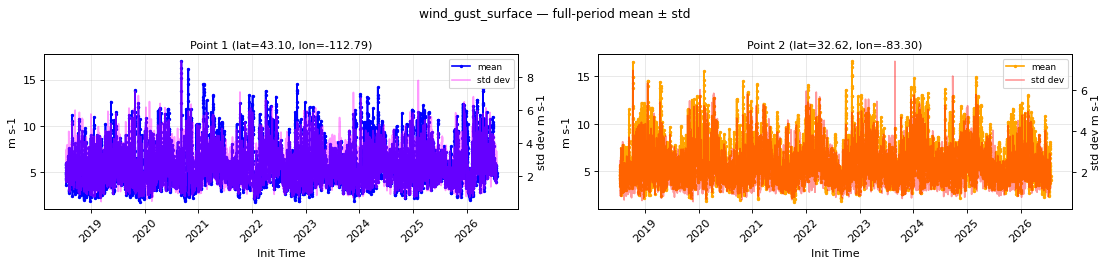
wind_gust_surface |
8235/11730 | 29.80% | 2018-07-13T12:00 | 2026-01-14T18:00 |
wind_u_10m |
8235/11730 | 29.80% | 2018-07-13T12:00 | 2026-01-14T18:00 |
wind_u_80m |
8235/11730 | 29.80% | 2018-07-13T12:00 | 2026-01-14T18:00 |
wind_v_10m |
8235/11730 | 29.80% | 2018-07-13T12:00 | 2026-01-14T18:00 |
wind_v_80m |
8235/11730 | 29.80% | 2018-07-13T12:00 | 2026-01-14T18:00 |
- Unavailable timestamps:
unavailable_timestamps.txt
Per-variable details
categorical_freezing_rain_surface
Metadata
| Field | Value |
|---|---|
| units | 1 |
| long_name | Categorical freezing rain |
| short_name | cfrzr |
| standard_name | n/a |
| step_type | instant |
| flag_values | 0, 1 |
| flag_meanings | no yes |
| comment | 0=no; 1=yes |
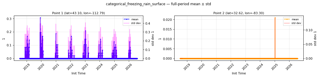
Point time series — 2018-07-13T12:00 - 2026-07-23T18:00
| Point | min | mean | std | max |
|---|---|---|---|---|
| P1 | 0 | 0.001842 | 0.006968 | 0.3056 |
| P2 | 0 | 1.778e-06 | 1.219e-05 | 0.02083 |
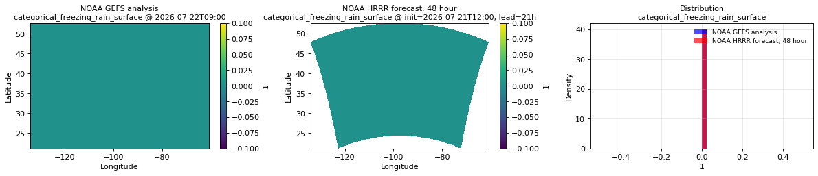
Spatial — init=2026-07-21T12:00, lead=21h (reference at 2026-07-22T09:00)
| Source | min | mean | max |
|---|---|---|---|
| Validation | 0 | 0 | 0 |
| Reference | 0 | 0 | 0 |
Temporal — init=2019-07-05T00:00
| Source | min | mean | max |
|---|---|---|---|
| P1 Validation | 0 | 0 | 0 |
| P1 Reference | n/a | n/a | n/a |
| P2 Validation | 0 | 0 | 0 |
| P2 Reference | n/a | n/a | n/a |
Availability — 8235 of 11730 positions complete (incomplete 2018-07-13T12:00 → 2026-01-14T18:00); nulls P1 42535/563040, P2 42535/563040
categorical_ice_pellets_surface
Metadata
| Field | Value |
|---|---|
| units | 1 |
| long_name | Categorical ice pellets |
| short_name | cicep |
| standard_name | n/a |
| step_type | instant |
| flag_values | 0, 1 |
| flag_meanings | no yes |
| comment | 0=no; 1=yes |
Point time series — 2018-07-13T12:00 - 2026-07-23T18:00
| Point | min | mean | std | max |
|---|---|---|---|---|
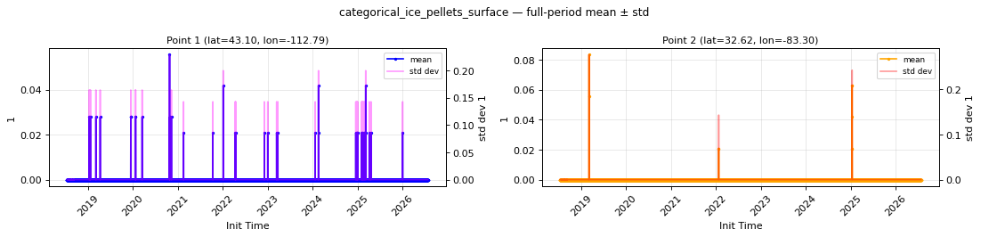
| P1 | 0 | 9.13e-05 | 0.0005598 | 0.05556 |
| P2 | 0 | 3.32e-05 | 0.0001503 | 0.08333 |
Spatial — init=2026-07-21T12:00, lead=21h (reference at 2026-07-22T09:00)
| Source | min | mean | max |
|---|---|---|---|
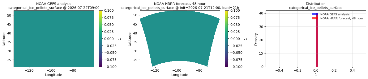
| Validation | 0 | 0 | 0 |
| Reference | 0 | 0 | 0 |
Temporal — init=2019-07-05T00:00
| Source | min | mean | max |
|---|---|---|---|
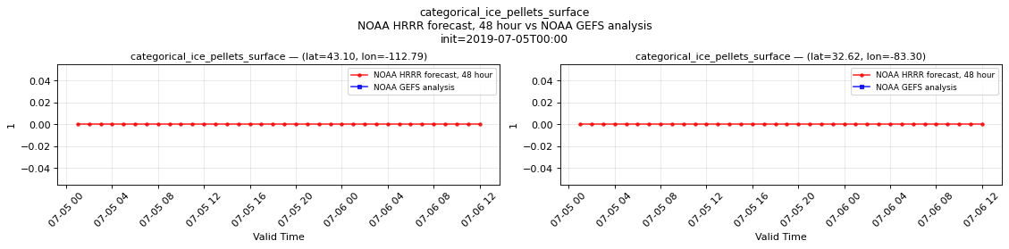
| P1 Validation | 0 | 0 | 0 |
| P1 Reference | n/a | n/a | n/a |
| P2 Validation | 0 | 0 | 0 |
| P2 Reference | n/a | n/a | n/a |
Availability — 8235 of 11730 positions complete (incomplete 2018-07-13T12:00 → 2026-01-14T18:00); nulls P1 42535/563040, P2 42535/563040
categorical_rain_surface
Metadata
| Field | Value |
|---|---|
| units | 1 |
| long_name | Categorical rain |
| short_name | crain |
| standard_name | n/a |
| step_type | instant |
| flag_values | 0, 1 |
| flag_meanings | no yes |
| comment | 0=no; 1=yes |
Point time series — 2018-07-13T12:00 - 2026-07-23T18:00
| Point | min | mean | std | max |
|---|---|---|---|---|
| P1 | 0 | 0.04791 | 0.1044 | 0.9167 |
| P2 | 0 | 0.1059 | 0.1928 | 1 |
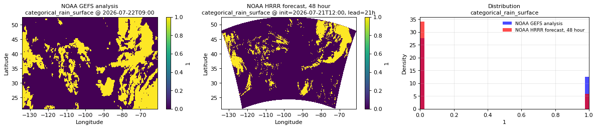
Spatial — init=2026-07-21T12:00, lead=21h (reference at 2026-07-22T09:00)
| Source | min | mean | max |
|---|---|---|---|
| Validation | 0 | 0.1454 | 1 |
| Reference | 0 | 0.3119 | 1 |
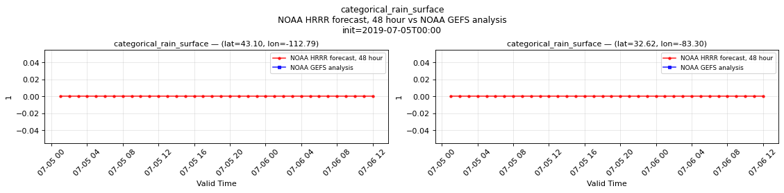
Temporal — init=2019-07-05T00:00
| Source | min | mean | max |
|---|---|---|---|
| P1 Validation | 0 | 0 | 0 |
| P1 Reference | n/a | n/a | n/a |
| P2 Validation | 0 | 0 | 0 |
| P2 Reference | n/a | n/a | n/a |
Availability — 8235 of 11730 positions complete (incomplete 2018-07-13T12:00 → 2026-01-14T18:00); nulls P1 42535/563040, P2 42535/563040
categorical_snow_surface
Metadata
| Field | Value |
|---|---|
| units | 1 |
| long_name | Categorical snow |
| short_name | csnow |
| standard_name | n/a |
| step_type | instant |
| flag_values | 0, 1 |
| flag_meanings | no yes |
| comment | 0=no; 1=yes |
Point time series — 2018-07-13T12:00 - 2026-07-23T18:00
| Point | min | mean | std | max |
|---|---|---|---|---|
| P1 | 0 | 0.04075 | 0.07151 | 0.8958 |
| P2 | 0 | 0.0003112 | 0.0008644 | 0.25 |
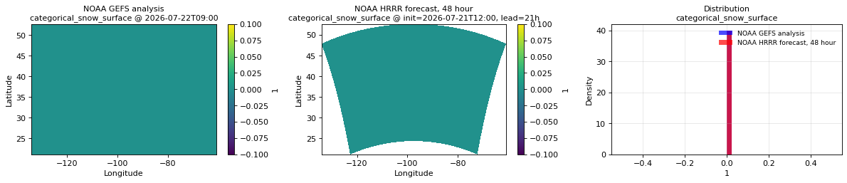
Spatial — init=2026-07-21T12:00, lead=21h (reference at 2026-07-22T09:00)
| Source | min | mean | max |
|---|---|---|---|
| Validation | 0 | 0 | 0 |
| Reference | 0 | 0 | 0 |
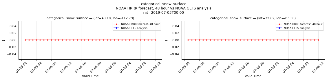
Temporal — init=2019-07-05T00:00
| Source | min | mean | max |
|---|---|---|---|
| P1 Validation | 0 | 0 | 0 |
| P1 Reference | n/a | n/a | n/a |
| P2 Validation | 0 | 0 | 0 |
| P2 Reference | n/a | n/a | n/a |
Availability — 8235 of 11730 positions complete (incomplete 2018-07-13T12:00 → 2026-01-14T18:00); nulls P1 42535/563040, P2 42535/563040
composite_reflectivity
Metadata
| Field | Value |
|---|---|
| units | dBZ |
| long_name | Maximum/Composite radar reflectivity |
| short_name | refc |
| standard_name | equivalent_reflectivity_factor |
| step_type | instant |
Point time series — 2018-07-13T12:00 - 2026-07-23T18:00
| Point | min | mean | std | max |
|---|---|---|---|---|
| P1 | -10 | -6.929 | 4.94 | 22.71 |
| P2 | -10 | -6.535 | 5.976 | 22.4 |
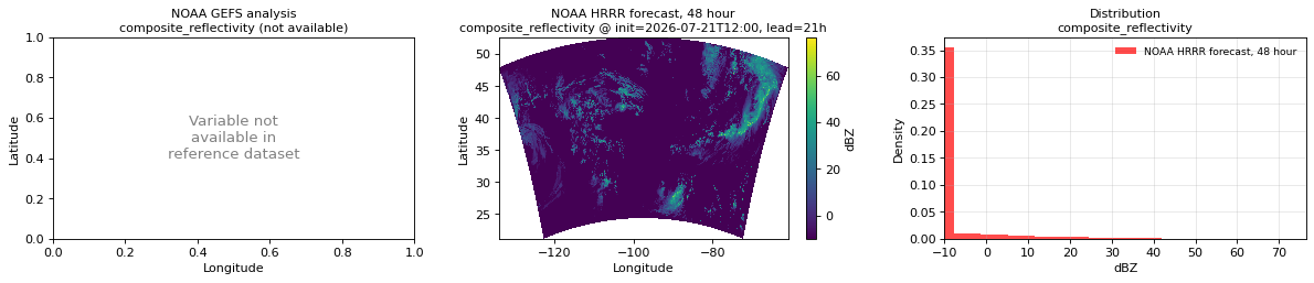
Spatial — init=2026-07-21T12:00, lead=21h (reference not available)
| Source | min | mean | max |
|---|---|---|---|
| Validation | -10 | -5.726 | 76.5 |
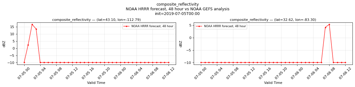
Temporal — init=2019-07-05T00:00
| Source | min | mean | max |
|---|---|---|---|
| P1 Validation | -10 | -8.311 | 16.75 |
| P2 Validation | -10 | -9.201 | 5.375 |
Availability — 8235 of 11730 positions complete (incomplete 2018-07-13T12:00 → 2026-01-14T18:00); nulls P1 42552/574770, P2 42552/574770
dew_point_temperature_2m
Metadata
| Field | Value |
|---|---|
| units | degree_Celsius |
| long_name | 2 metre dewpoint temperature |
| short_name | 2d |
| standard_name | dew_point_temperature |
| step_type | instant |
Point time series — 2018-07-13T12:00 - 2026-07-23T18:00
| Point | min | mean | std | max |
|---|---|---|---|---|
| P1 | -24.74 | -2.396 | 2.722 | 14.27 |
| P2 | -18.29 | 12.02 | 2.594 | 24.76 |
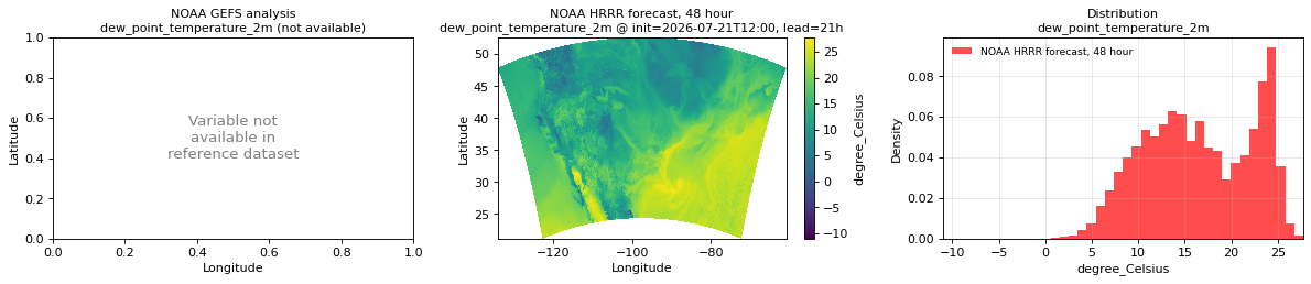
Spatial — init=2026-07-21T12:00, lead=21h (reference not available)
| Source | min | mean | max |
|---|---|---|---|
| Validation | -11.06 | 16.51 | 27.75 |
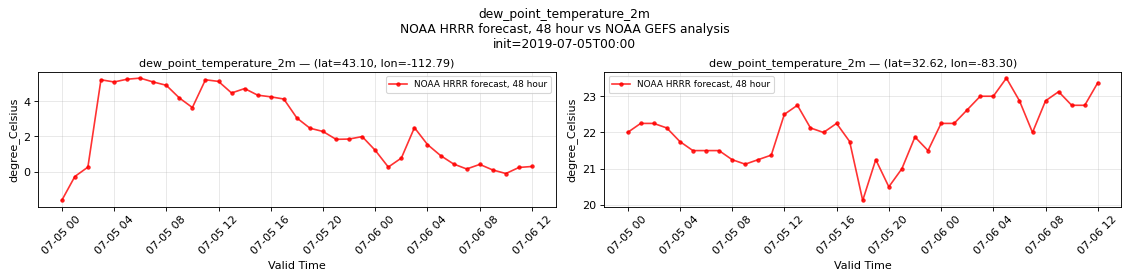
Temporal — init=2019-07-05T00:00
| Source | min | mean | max |
|---|---|---|---|
| P1 Validation | -1.633 | 2.473 | 5.312 |
| P2 Validation | 20.12 | 22.05 | 23.5 |
Availability — 8235 of 11730 positions complete (incomplete 2018-07-13T12:00 → 2026-01-14T18:00); nulls P1 42553/574770, P2 42553/574770
downward_long_wave_radiation_flux_surface
Metadata
| Field | Value |
|---|---|
| units | W m-2 |
| long_name | Surface downward long-wave radiation flux |
| short_name | sdlwrf |
| standard_name | surface_downwelling_longwave_flux_in_air |
| step_type | instant |
Point time series — 2018-07-13T12:00 - 2026-07-23T18:00
| Point | min | mean | std | max |
|---|---|---|---|---|
| P1 | 157.6 | 278.1 | 23.25 | 390.9 |
| P2 | 195.6 | 351 | 24.29 | 440.5 |
Spatial — init=2026-07-21T12:00, lead=21h (reference at 2026-07-22T09:00)
| Source | min | mean | max |
|---|---|---|---|
| Validation | 248 | 377.3 | 472 |
| Reference | 264 | 368.1 | 452 |
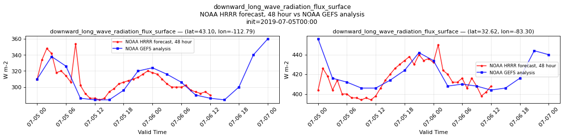
Temporal — init=2019-07-05T00:00
| Source | min | mean | max |
|---|---|---|---|
| P1 Validation | 284 | 307.2 | 354 |
| P1 Reference | 284 | 308.8 | 360 |
| P2 Validation | 394 | 414.9 | 450 |
| P2 Reference | 404 | 420.4 | 456 |
Availability — 8235 of 11730 positions complete (incomplete 2018-07-13T12:00 → 2026-01-14T18:00); nulls P1 42552/574770, P2 42552/574770
downward_short_wave_radiation_flux_surface
Metadata
| Field | Value |
|---|---|
| units | W m-2 |
| long_name | Surface downward short-wave radiation flux |
| short_name | sdswrf |
| standard_name | surface_downwelling_shortwave_flux_in_air |
| step_type | instant |
Point time series — 2018-07-13T12:00 - 2026-07-23T18:00
| Point | min | mean | std | max |
|---|---|---|---|---|
| P1 | 28.73 | 212.3 | 261.3 | 490 |
| P2 | 8.831 | 207.5 | 270.7 | 465.2 |
Spatial — init=2026-07-21T12:00, lead=21h (reference at 2026-07-22T09:00)
| Source | min | mean | max |
|---|---|---|---|
| Validation | 0 | 0.02391 | 27.12 |
| Reference | 0 | 0.01761 | 5.688 |
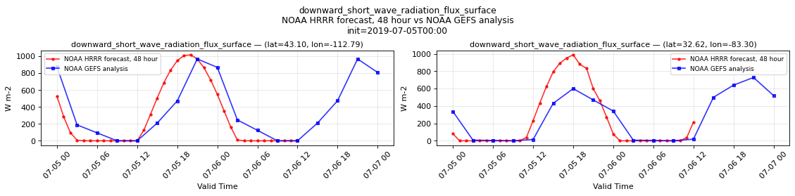
Temporal — init=2019-07-05T00:00
| Source | min | mean | max |
|---|---|---|---|
| P1 Validation | 0 | 269.8 | 1016 |
| P1 Reference | 0 | 382.5 | 968 |
| P2 Validation | 0 | 227.2 | 988 |
| P2 Reference | 0 | 271.9 | 728 |
Availability — 8235 of 11730 positions complete (incomplete 2018-07-13T12:00 → 2026-01-14T18:00); nulls P1 42552/574770, P2 42552/574770
geopotential_height_cloud_ceiling
Metadata
| Field | Value |
|---|---|
| units | m |
| long_name | Geopotential height |
| short_name | gh |
| standard_name | geopotential_height |
| step_type | instant |
| comment | NaN where no cloud ceiling was detected. |
Point time series — 2018-07-13T12:00 - 2026-07-23T18:00
| Point | min | mean | std | max |
|---|---|---|---|---|
| P1 | 1416 | 8397 | 1760 | 1.115e+04 |
| P2 | 238.6 | 7992 | 2559 | 1.163e+04 |
Spatial — init=2026-07-21T12:00, lead=21h (reference at 2026-07-22T09:00)
| Source | min | mean | max |
|---|---|---|---|
| Validation | 38.25 | 7502 | 1.6e+04 |
| Reference | 26.88 | 1.498e+04 | 1.997e+04 |
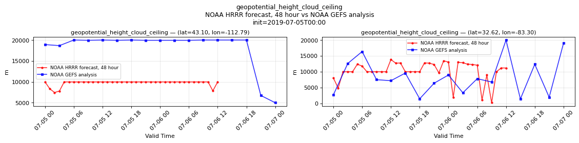
Temporal — init=2019-07-05T00:00
| Source | min | mean | max |
|---|---|---|---|
| P1 Validation | 7440 | 9754 | 9984 |
| P1 Reference | 4992 | 1.82e+04 | 2.003e+04 |
| P2 Validation | 177.5 | 1.019e+04 | 1.386e+04 |
| P2 Reference | 1364 | 8540 | 2.003e+04 |
Availability — 8235 of 11730 positions complete (incomplete 2018-07-13T12:00 → 2026-01-14T18:00); nulls P1 42552/574770, P2 42552/574770
percent_frozen_precipitation_surface
Metadata
| Field | Value |
|---|---|
| units | percent |
| long_name | Percent frozen precipitation |
| short_name | cpofp |
| standard_name | n/a |
| step_type | instant |
| comment | NaN where there is no precipitation. |
Point time series — 2018-07-13T12:00 - 2026-07-23T18:00
| Point | min | mean | std | max |
|---|---|---|---|---|
| P1 | 0 | 37.56 | 6.286 | 100 |
| P2 | 0 | 0.4498 | 0.1058 | 100 |
Spatial — init=2026-07-21T12:00, lead=21h (reference at 2026-07-22T09:00)
| Source | min | mean | max |
|---|---|---|---|
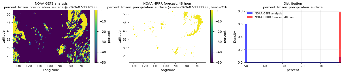
| Validation | 0 | 1.923e-05 | 1 |
| Reference | -50 | -41.52 | -6.109e-06 |
Temporal — init=2019-07-05T00:00
| Source | min | mean | max |
|---|---|---|---|
| P1 Validation | n/a | n/a | n/a |
| P1 Reference | n/a | n/a | n/a |
| P2 Validation | n/a | n/a | n/a |
| P2 Reference | n/a | n/a | n/a |
Availability — 8235 of 11730 positions complete (incomplete 2018-07-13T12:00 → 2026-01-14T18:00)
precipitable_water_atmosphere
Metadata
| Field | Value |
|---|---|
| units | kg m-2 |
| long_name | Precipitable water |
| short_name | pwat |
| standard_name | atmosphere_mass_content_of_water_vapor |
| step_type | instant |
Point time series — 2018-07-13T12:00 - 2026-07-23T18:00
| Point | min | mean | std | max |
|---|---|---|---|---|
| P1 | 1.67 | 10.28 | 1.894 | 34.47 |
| P2 | 3.066 | 27.11 | 4.825 | 58.57 |
Spatial — init=2026-07-21T12:00, lead=21h (reference at 2026-07-22T09:00)
| Source | min | mean | max |
|---|---|---|---|
| Validation | 6.812 | 34.59 | 82 |
| Reference | 9 | 33.58 | 71.5 |
Temporal — init=2019-07-05T00:00
| Source | min | mean | max |
|---|---|---|---|
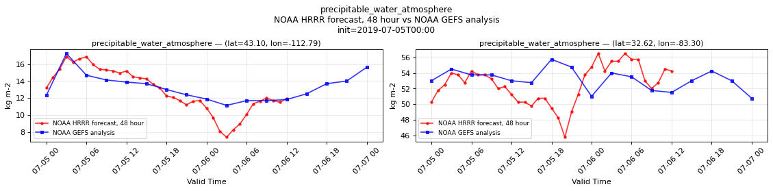
| P1 Validation | 7.375 | 12.85 | 16.88 |
| P1 Reference | 11.12 | 13.25 | 17.25 |
| P2 Validation | 45.75 | 52.59 | 56.5 |
| P2 Reference | 50.75 | 53.18 | 55.75 |
Availability — 8235 of 11730 positions complete (incomplete 2018-07-13T12:00 → 2026-01-14T18:00); nulls P1 42552/574770, P2 42552/574770
precipitation_surface
Metadata
| Field | Value |
|---|---|
| units | kg m-2 s-1 |
| long_name | Precipitation rate |
| short_name | prate |
| standard_name | precipitation_flux |
| step_type | avg |
| comment | Average precipitation rate since the previous forecast step. Units equivalent to mm/s. |
Point time series — 2018-07-13T12:00 - 2026-07-23T18:00
| Point | min | mean | std | max |
|---|---|---|---|---|
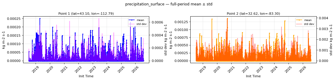
| P1 | 0 | 8.023e-06 | 2.181e-05 | 0.0002491 |
| P2 | 0 | 3.751e-05 | 0.000129 | 0.001354 |
Spatial — init=2026-07-21T12:00, lead=21h (reference at 2026-07-22T09:00)
| Source | min | mean | max |
|---|---|---|---|
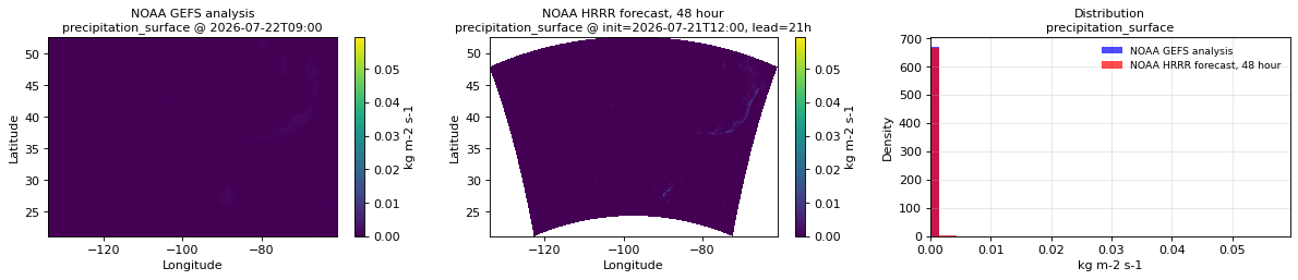
| Validation | 0 | 5.174e-05 | 0.05957 |
| Reference | 0 | 3.668e-05 | 0.001625 |
Temporal — init=2019-07-05T00:00
| Source | min | mean | max |
|---|---|---|---|
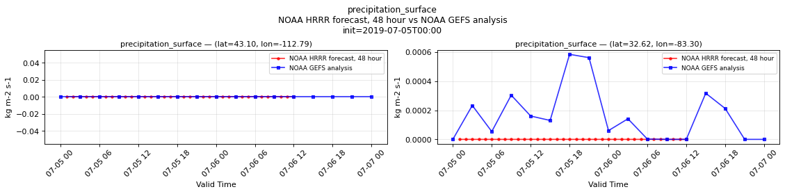
| P1 Validation | 0 | 0 | 0 |
| P1 Reference | 0 | 0 | 0 |
| P2 Validation | 0 | 7.709e-09 | 2.775e-07 |
| P2 Reference | 0 | 0.0001621 | 0.0005836 |
Availability — 8235 of 11730 positions complete (incomplete 2018-07-13T12:00 → 2026-01-14T18:00); nulls P1 42535/563040, P2 42535/563040
pressure_reduced_to_mean_sea_level
Metadata
| Field | Value |
|---|---|
| units | Pa |
| long_name | Pressure reduced to MSL |
| short_name | prmsl |
| standard_name | air_pressure_at_mean_sea_level |
| step_type | instant |
Point time series — 2018-07-13T12:00 - 2026-07-23T18:00
| Point | min | mean | std | max |
|---|---|---|---|---|
| P1 | 9.933e+04 | 1.015e+05 | 328.7 | 1.041e+05 |
| P2 | 9.971e+04 | 1.018e+05 | 205.3 | 1.035e+05 |
Spatial — init=2026-07-21T12:00, lead=21h (reference at 2026-07-22T09:00)
| Source | min | mean | max |
|---|---|---|---|
| Validation | 9.941e+04 | 1.012e+05 | 1.024e+05 |
| Reference | 9.92e+04 | 1.014e+05 | 1.025e+05 |
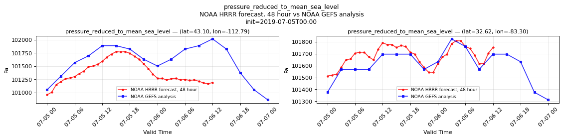
Temporal — init=2019-07-05T00:00
| Source | min | mean | max |
|---|---|---|---|
| P1 Validation | 1.01e+05 | 1.014e+05 | 1.018e+05 |
| P1 Reference | 1.009e+05 | 1.016e+05 | 1.02e+05 |
| P2 Validation | 1.015e+05 | 1.017e+05 | 1.018e+05 |
| P2 Reference | 1.013e+05 | 1.016e+05 | 1.018e+05 |
Availability — 8235 of 11730 positions complete (incomplete 2018-07-13T12:00 → 2026-01-14T18:00); nulls P1 42552/574770, P2 42552/574770
pressure_surface
Metadata
| Field | Value |
|---|---|
| units | Pa |
| long_name | Surface pressure |
| short_name | sp |
| standard_name | surface_air_pressure |
| step_type | instant |
Point time series — 2018-07-13T12:00 - 2026-07-23T18:00
| Point | min | mean | std | max |
|---|---|---|---|---|
| P1 | 8.43e+04 | 8.64e+04 | 244.7 | 8.819e+04 |
| P2 | 9.81e+04 | 1.001e+05 | 202.1 | 1.018e+05 |
Spatial — init=2026-07-21T12:00, lead=21h (reference at 2026-07-22T09:00)
| Source | min | mean | max |
|---|---|---|---|
| Validation | 6.365e+04 | 9.615e+04 | 1.024e+05 |
| Reference | 6.867e+04 | 9.685e+04 | 1.025e+05 |
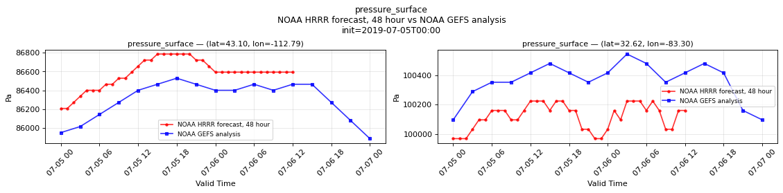
Temporal — init=2019-07-05T00:00
| Source | min | mean | max |
|---|---|---|---|
| P1 Validation | 8.621e+04 | 8.658e+04 | 8.678e+04 |
| P1 Reference | 8.589e+04 | 8.63e+04 | 8.653e+04 |
| P2 Validation | 9.997e+04 | 1.001e+05 | 1.002e+05 |
| P2 Reference | 1.001e+05 | 1.004e+05 | 1.005e+05 |
Availability — 8235 of 11730 positions complete (incomplete 2018-07-13T12:00 → 2026-01-14T18:00); nulls P1 42552/574770, P2 42552/574770
relative_humidity_2m
Metadata
| Field | Value |
|---|---|
| units | percent |
| long_name | 2 metre relative humidity |
| short_name | 2r |
| standard_name | relative_humidity |
| step_type | instant |
Point time series — 2018-07-13T12:00 - 2026-07-23T18:00
| Point | min | mean | std | max |
|---|---|---|---|---|
| P1 | 11.92 | 52.41 | 13.88 | 95.43 |
| P2 | 21.41 | 66.94 | 14.47 | 97.32 |
Spatial — init=2026-07-21T12:00, lead=21h (reference at 2026-07-22T09:00)
| Source | min | mean | max |
|---|---|---|---|
| Validation | 9.688 | 75.21 | 100 |
| Reference | 20.75 | 77.65 | 100 |
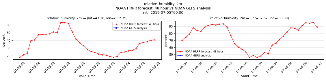
Temporal — init=2019-07-05T00:00
| Source | min | mean | max |
|---|---|---|---|
| P1 Validation | 17.75 | 35.38 | 63.25 |
| P1 Reference | n/a | n/a | n/a |
| P2 Validation | 45.75 | 75.91 | 95.5 |
| P2 Reference | n/a | n/a | n/a |
Availability — 8235 of 11730 positions complete (incomplete 2018-07-13T12:00 → 2026-01-14T18:00); nulls P1 42552/574770, P2 42552/574770
snow_area_fraction_surface
Metadata
| Field | Value |
|---|---|
| units | 1 |
| long_name | Snow cover |
| short_name | snowc |
| standard_name | surface_snow_area_fraction |
| step_type | instant |
Point time series — 2018-07-13T12:00 - 2026-07-23T18:00
| Point | min | mean | std | max |
|---|---|---|---|---|
| P1 | 0 | 0.1476 | 0.05954 | 1 |
| P2 | 0 | 0.0006364 | 0.001148 | 0.4898 |
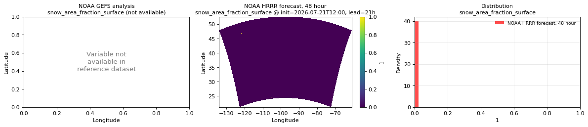
Spatial — init=2026-07-21T12:00, lead=21h (reference not available)
| Source | min | mean | max |
|---|---|---|---|
| Validation | 0 | 9.081e-05 | 1 |
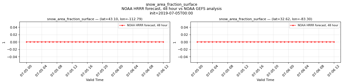
Temporal — init=2019-07-05T00:00
| Source | min | mean | max |
|---|---|---|---|
| P1 Validation | 0 | 0 | 0 |
| P2 Validation | 0 | 0 | 0 |
Availability — 8235 of 11730 positions complete (incomplete 2018-07-13T12:00 → 2026-01-14T18:00); nulls P1 42553/574770, P2 42553/574770
snow_thickness_surface
Metadata
| Field | Value |
|---|---|
| units | m |
| long_name | Snow depth |
| short_name | sde |
| standard_name | surface_snow_thickness |
| step_type | instant |
Point time series — 2018-07-13T12:00 - 2026-07-23T18:00
| Point | min | mean | std | max |
|---|---|---|---|---|
| P1 | 0 | 0.007482 | 0.001844 | 0.2866 |
| P2 | 0 | 1.76e-05 | 2.809e-05 | 0.02814 |
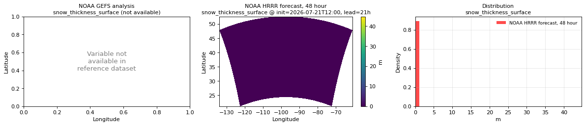
Spatial — init=2026-07-21T12:00, lead=21h (reference not available)
| Source | min | mean | max |
|---|---|---|---|
| Validation | 0 | 0.0004272 | 44.75 |
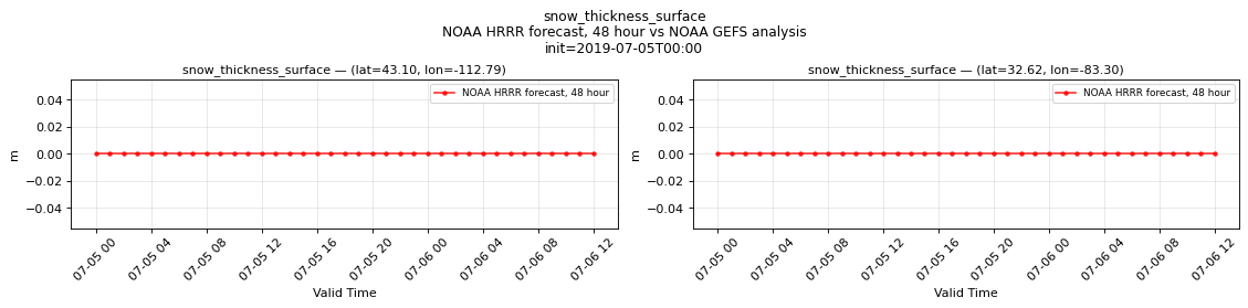
Temporal — init=2019-07-05T00:00
| Source | min | mean | max |
|---|---|---|---|
| P1 Validation | 0 | 0 | 0 |
| P2 Validation | 0 | 0 | 0 |
Availability — 8235 of 11730 positions complete (incomplete 2018-07-13T12:00 → 2026-01-14T18:00); nulls P1 42553/574770, P2 42553/574770
snow_water_equivalent_surface
Metadata
| Field | Value |
|---|---|
| units | m |
| long_name | Snow depth water equivalent |
| short_name | sd |
| standard_name | lwe_thickness_of_surface_snow_amount |
| step_type | instant |
Point time series — 2018-07-13T12:00 - 2026-07-23T18:00
| Point | min | mean | std | max |
|---|---|---|---|---|
| P1 | 0 | 0.001069 | 0.0002205 | 0.03733 |
| P2 | 0 | 1.761e-06 | 2.907e-06 | 0.002621 |
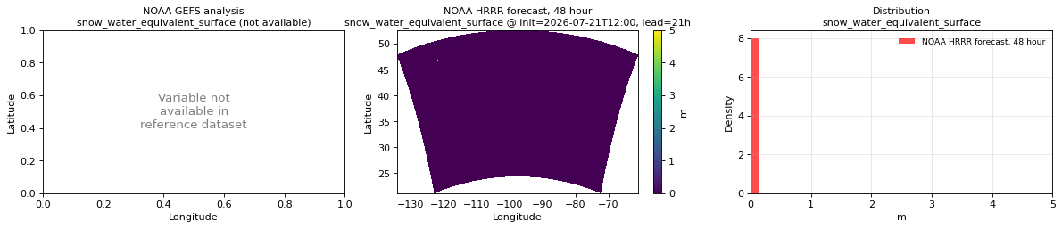
Spatial — init=2026-07-21T12:00, lead=21h (reference not available)
| Source | min | mean | max |
|---|---|---|---|
| Validation | 0 | 0.0001029 | 5 |
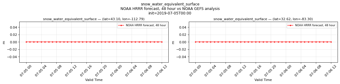
Temporal — init=2019-07-05T00:00
| Source | min | mean | max |
|---|---|---|---|
| P1 Validation | 0 | 0 | 0 |
| P2 Validation | 0 | 0 | 0 |
Availability — 8235 of 11730 positions complete (incomplete 2018-07-13T12:00 → 2026-01-14T18:00); nulls P1 42553/574770, P2 42553/574770
snowfall_surface
Metadata
| Field | Value |
|---|---|
| units | m s-1 |
| long_name | Total snowfall rate |
| short_name | tsrate |
| standard_name | n/a |
| step_type | avg |
| comment | Average snowfall rate since the previous forecast step. |
Point time series — 2018-07-13T12:00 - 2026-07-23T18:00
| Point | min | mean | std | max |
|---|---|---|---|---|
| P1 | 0 | 2.749e-08 | 7.176e-08 | 2.053e-06 |
| P2 | 0 | 4.572e-10 | 1.501e-09 | 6.004e-07 |
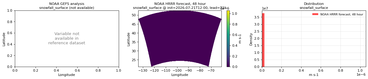
Spatial — init=2026-07-21T12:00, lead=21h (reference not available)
| Source | min | mean | max |
|---|---|---|---|
| Validation | 0 | 1.94e-12 | 1.058e-06 |
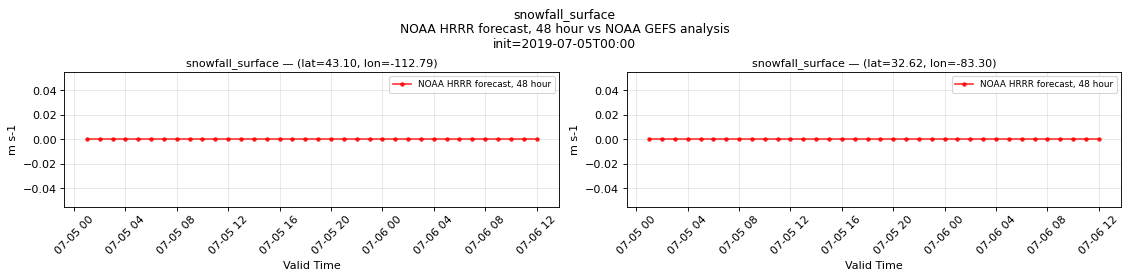
Temporal — init=2019-07-05T00:00
| Source | min | mean | max |
|---|---|---|---|
| P1 Validation | 0 | 0 | 0 |
| P2 Validation | 0 | 0 | 0 |
Availability — 8235 of 11730 positions complete (incomplete 2018-07-13T12:00 → 2026-01-14T18:00); nulls P1 42549/563040, P2 42549/563040
temperature_2m
Metadata
| Field | Value |
|---|---|
| units | degree_Celsius |
| long_name | 2 metre temperature |
| short_name | 2t |
| standard_name | air_temperature |
| step_type | instant |
Point time series — 2018-07-13T12:00 - 2026-07-23T18:00
| Point | min | mean | std | max |
|---|---|---|---|---|
| P1 | -15.57 | 8.956 | 4.862 | 29.45 |
| P2 | -5.744 | 18.98 | 3.847 | 33.14 |
Spatial — init=2026-07-21T12:00, lead=21h (reference at 2026-07-22T09:00)
| Source | min | mean | max |
|---|---|---|---|
| Validation | 1.812 | 20.97 | 38.5 |
| Reference | 4.938 | 20.47 | 33.75 |
Temporal — init=2019-07-05T00:00
| Source | min | mean | max |
|---|---|---|---|
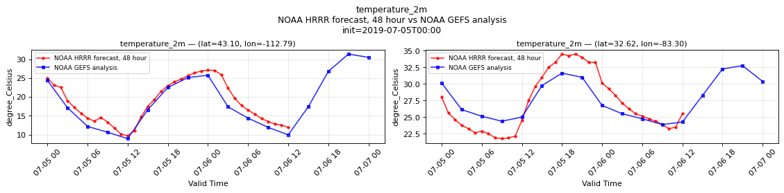
| P1 Validation | 9.688 | 18.42 | 27.12 |
| P1 Reference | 8.938 | 18.99 | 31.38 |
| P2 Validation | 21.75 | 27.02 | 34.5 |
| P2 Reference | 23.88 | 27.76 | 32.75 |
Availability — 8235 of 11730 positions complete (incomplete 2018-07-13T12:00 → 2026-01-14T18:00); nulls P1 42552/574770, P2 42552/574770
total_cloud_cover_atmosphere
Metadata
| Field | Value |
|---|---|
| units | percent |
| long_name | Total cloud cover |
| short_name | tcc |
| standard_name | cloud_area_fraction |
| step_type | instant |
Point time series — 2018-07-13T12:00 - 2026-07-23T18:00
| Point | min | mean | std | max |
|---|---|---|---|---|
| P1 | 0 | 48.7 | 31.58 | 100 |
| P2 | 0 | 48.13 | 31.67 | 100 |
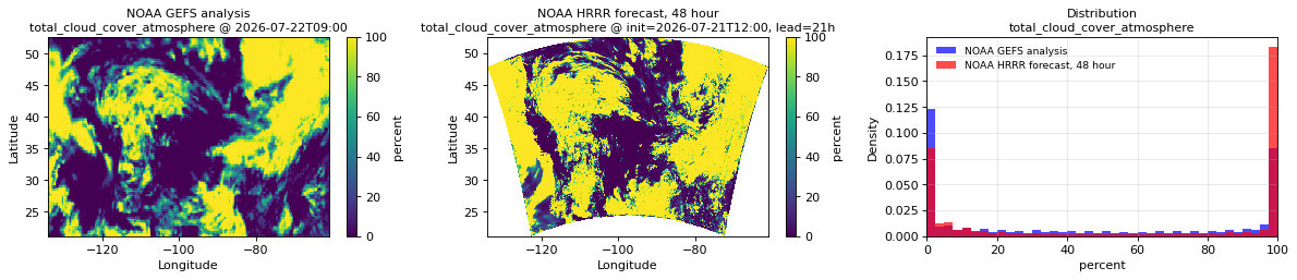
Spatial — init=2026-07-21T12:00, lead=21h (reference at 2026-07-22T09:00)
| Source | min | mean | max |
|---|---|---|---|
| Validation | 0 | 59.22 | 100 |
| Reference | 0 | 43.98 | 100 |
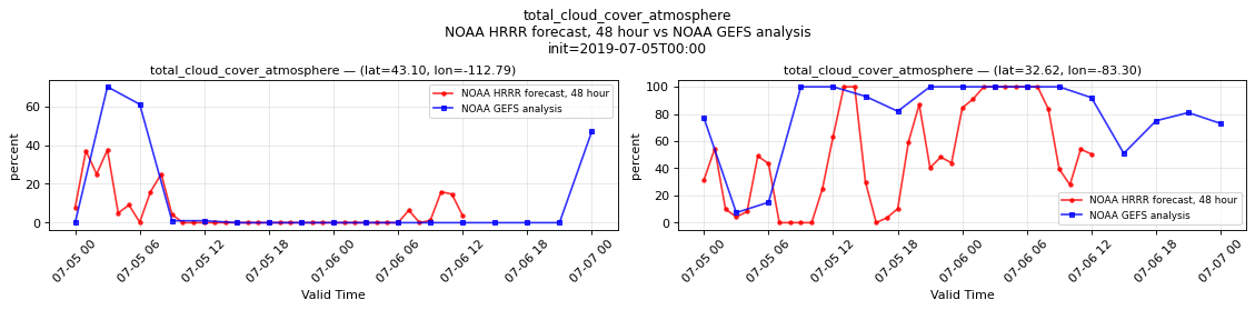
Temporal — init=2019-07-05T00:00
| Source | min | mean | max |
|---|---|---|---|
| P1 Validation | 0 | 5.639 | 37.5 |
| P1 Reference | 0 | 10.59 | 70 |
| P2 Validation | 0 | 49.82 | 100 |
| P2 Reference | 7.406 | 79.2 | 100 |
Availability — 8235 of 11730 positions complete (incomplete 2018-07-13T12:00 → 2026-01-14T18:00); nulls P1 42552/574770, P2 42552/574770
wind_gust_surface
Metadata
| Field | Value |
|---|---|
| units | m s-1 |
| long_name | Wind speed (gust) |
| short_name | gust |
| standard_name | wind_speed_of_gust |
| step_type | instant |
Point time series — 2018-07-13T12:00 - 2026-07-23T18:00
| Point | min | mean | std | max |
|---|---|---|---|---|
| P1 | 1.82 | 5.744 | 2.711 | 16.96 |
| P2 | 1.828 | 6.147 | 2.198 | 16.58 |
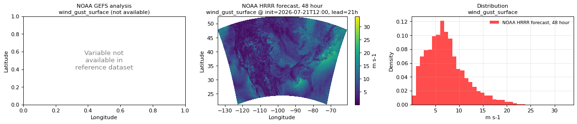
Spatial — init=2026-07-21T12:00, lead=21h (reference not available)
| Source | min | mean | max |
|---|---|---|---|
| Validation | 0.04834 | 7.234 | 34 |
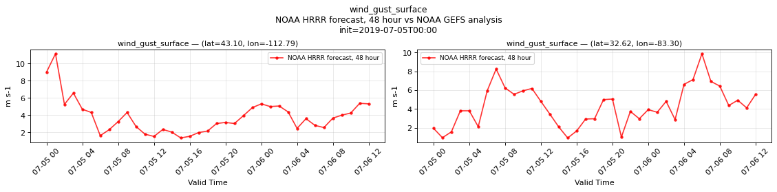
Temporal — init=2019-07-05T00:00
| Source | min | mean | max |
|---|---|---|---|
| P1 Validation | 1.359 | 3.829 | 11.12 |
| P2 Validation | 0.9297 | 4.333 | 9.875 |
Availability — 8235 of 11730 positions complete (incomplete 2018-07-13T12:00 → 2026-01-14T18:00); nulls P1 42552/574770, P2 42552/574770
wind_u_10m
Metadata
| Field | Value |
|---|---|
| units | m s-1 |
| long_name | 10 metre U wind component |
| short_name | 10u |
| standard_name | x_wind |
| step_type | instant |
| comment | Velocity along the model grid's x dimension, not eastward velocity. |
Point time series — 2018-07-13T12:00 - 2026-07-23T18:00
| Point | min | mean | std | max |
|---|---|---|---|---|
| P1 | -6.213 | 1.248 | 2.247 | 8.636 |
| P2 | -4.985 | 0.3843 | 1.536 | 6.152 |
Spatial — init=2026-07-21T12:00, lead=21h (reference at 2026-07-22T09:00)
| Source | min | mean | max |
|---|---|---|---|
| Validation | -18.5 | 0.09113 | 21.5 |
| Reference | -11.62 | -0.1204 | 13.5 |
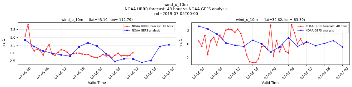
Temporal — init=2019-07-05T00:00
| Source | min | mean | max |
|---|---|---|---|
| P1 Validation | -1.562 | 0.2533 | 9.125 |
| P1 Reference | -3.062 | 0.3077 | 4.125 |
| P2 Validation | -2.688 | 0.133 | 2.812 |
| P2 Reference | -1.172 | 0.3144 | 2.562 |
Availability — 8235 of 11730 positions complete (incomplete 2018-07-13T12:00 → 2026-01-14T18:00); nulls P1 42552/574770, P2 42552/574770
wind_u_80m
Metadata
| Field | Value |
|---|---|
| units | m s-1 |
| long_name | 80 metre U wind component |
| short_name | 80u |
| standard_name | x_wind |
| step_type | instant |
| comment | Velocity along the model grid's x dimension, not eastward velocity. |
Point time series — 2018-07-13T12:00 - 2026-07-23T18:00
| Point | min | mean | std | max |
|---|---|---|---|---|
| P1 | -8.673 | 1.792 | 3.204 | 13.67 |
| P2 | -8.522 | 0.5997 | 2.638 | 9.536 |
Spatial — init=2026-07-21T12:00, lead=21h (reference at 2026-07-22T09:00)
| Source | min | mean | max |
|---|---|---|---|
| Validation | -21.25 | 0.258 | 27 |
| Reference | -12.62 | 0.02171 | 16.75 |
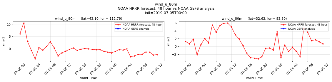
Temporal — init=2019-07-05T00:00
| Source | min | mean | max |
|---|---|---|---|
| P1 Validation | -4.125 | -0.3373 | 10.5 |
| P1 Reference | n/a | n/a | n/a |
| P2 Validation | -3.188 | 0.9752 | 6 |
| P2 Reference | n/a | n/a | n/a |
Availability — 8235 of 11730 positions complete (incomplete 2018-07-13T12:00 → 2026-01-14T18:00); nulls P1 42552/574770, P2 42552/574770
wind_v_10m
Metadata
| Field | Value |
|---|---|
| units | m s-1 |
| long_name | 10 metre V wind component |
| short_name | 10v |
| standard_name | y_wind |
| step_type | instant |
| comment | Velocity along the model grid's y dimension, not northward velocity. |
Point time series — 2018-07-13T12:00 - 2026-07-23T18:00
| Point | min | mean | std | max |
|---|---|---|---|---|
| P1 | -7.229 | 0.04735 | 2.039 | 5.128 |
| P2 | -5.679 | 0.1465 | 1.474 | 5.312 |
Spatial — init=2026-07-21T12:00, lead=21h (reference at 2026-07-22T09:00)
| Source | min | mean | max |
|---|---|---|---|
| Validation | -15.5 | 0.7333 | 20.25 |
| Reference | -17.25 | 0.4807 | 16.5 |
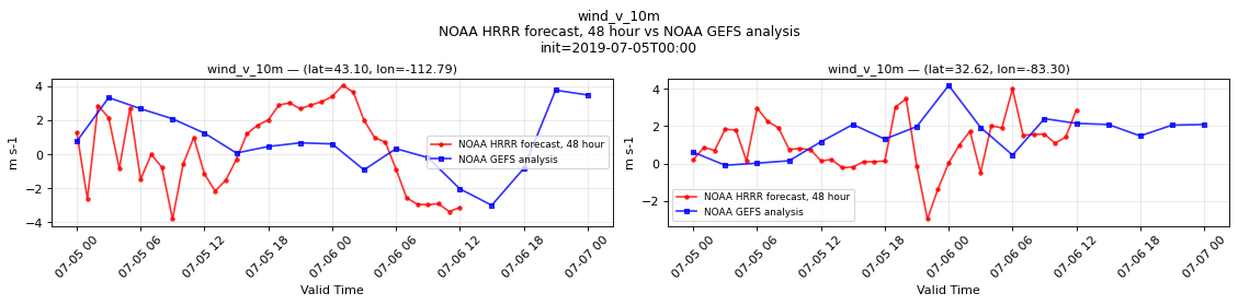
Temporal — init=2019-07-05T00:00
| Source | min | mean | max |
|---|---|---|---|
| P1 Validation | -3.812 | 0.2835 | 4.062 |
| P1 Reference | -3 | 0.7426 | 3.781 |
| P2 Validation | -2.969 | 1.018 | 4 |
| P2 Reference | -0.08789 | 1.538 | 4.188 |
Availability — 8235 of 11730 positions complete (incomplete 2018-07-13T12:00 → 2026-01-14T18:00); nulls P1 42552/574770, P2 42552/574770
wind_v_80m
Metadata
| Field | Value |
|---|---|
| units | m s-1 |
| long_name | 80 metre V wind component |
| short_name | 80v |
| standard_name | y_wind |
| step_type | instant |
| comment | Velocity along the model grid's y dimension, not northward velocity. |
Point time series — 2018-07-13T12:00 - 2026-07-23T18:00
| Point | min | mean | std | max |
|---|---|---|---|---|
| P1 | -10.61 | 0.1935 | 2.961 | 10.27 |
| P2 | -9.719 | 0.3487 | 2.711 | 9.169 |
Spatial — init=2026-07-21T12:00, lead=21h (reference at 2026-07-22T09:00)
| Source | min | mean | max |
|---|---|---|---|
| Validation | -19.5 | 1.086 | 28.25 |
| Reference | -21.25 | 0.6532 | 19 |
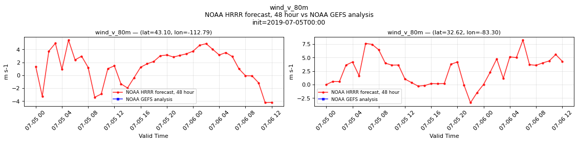
Temporal — init=2019-07-05T00:00
| Source | min | mean | max |
|---|---|---|---|
| P1 Validation | -4.25 | 1.364 | 5.438 |
| P1 Reference | n/a | n/a | n/a |
| P2 Validation | -3.375 | 2.694 | 8.25 |
| P2 Reference | n/a | n/a | n/a |
Availability — 8235 of 11730 positions complete (incomplete 2018-07-13T12:00 → 2026-01-14T18:00); nulls P1 42552/574770, P2 42552/574770